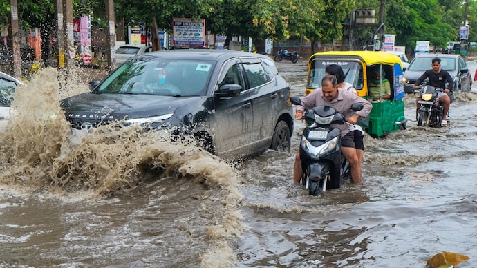
There is frequent confusion about how a few hours of rain can transform gurugram into an aquatic wonderland. However, flooding in Gurugram is a natural occurrence. Water flowing downhill is as natural as it is. Roads crisscrossed the Sahibi River’s catchment area and the water bodies as Gurgaon transformed into Gurugram, creating a dense concrete jungle on the Aravallis slope. A flooded Gurgaon, therefore, shouldn’t surprise anyone.
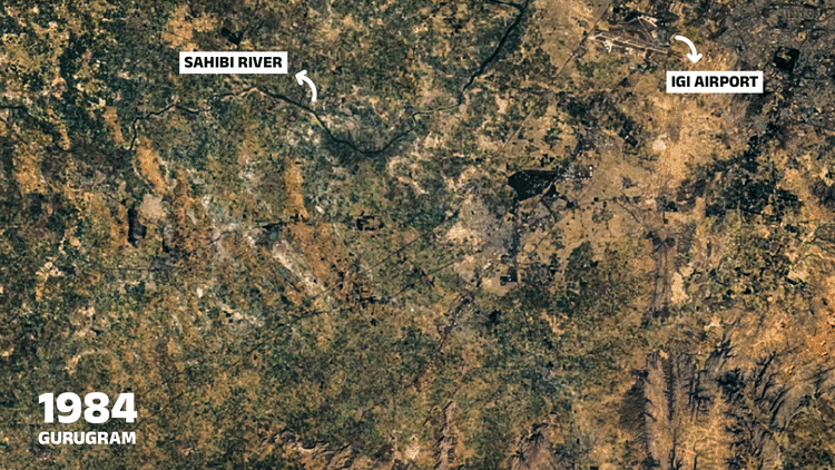
Up till 20 years ago, Gurgaon was more of a gaon (village). The satellite imagery of Gurgaon (from 1984 to 2022 here) reveals how the topography changed from vast expanses of open fields with multiple water bodies to one that is now a carpet of grey because of the rampant construction.
On the slope of the Aravalli Hills, Gurgaon expanded by adding sector after sector and building after building.
Gurgaon’s natural slope faces the Sahibi River, which forms the two-part border between Delhi and the Haryana district of Gurugram.
The blocked Najafgarh Nullah is the Sahibi River, which has been reduced to a drain and flows into Delhi.
Rainwater used to naturally flow from the Aravallis to the Sahibi River’s catchment area in Gurgaon. The Sahibi is still depicted on government maps as a crucial component of Haryana’s drainage and irrigation system, especially in the nearby Rewari district of Gurugram.
And the Sahibi River isn’t the only factor. The majority of Gurgaon’s water bodies have either been completely engulfed or severely restricted as a result of the rapid development.
GOBBLED UP WATER BODIES IN GURGAON
Vinit Bhanwala, a specialist in hydrological archaeology, tells India Today Digital that Gurgaon had hundreds of little ponds and baolis (step wells) that collected rainwater prior to its explosive growth in the 1990s.
According to Bhanwala, some of the water bodies may have been connected to the Sahibi River, although there is no documentation to support this. The topography of Gurugram in 1984 and 2022 is contrasted. (Photo courtesy of google Earth Engine)

“But they certainly served as reservoirs for rainwater,” adds Bhanwal, and he continues, “When Gurgaon was still a village, farmers relied on them for irrigating their fields.”
Consider the Sukhrali pond, for instance. Although it is currently referred to as a “lake” by the Gurugram Municipal Corporation, it is actually a collection of small and large ponds that served as water storage sites. According to a 2013 study in The Times of India, there were 75 such water basins in Gurgaon, all of which have since vanished or diminished.
Rainwater that would have normally poured into the ponds and lakes along the Aravallis’ gradient does not have an unhindered path or bodies of water to discharge into.
The layer of dirt that previously absorbed some of the precipitation has also been obscured by Gurgaon’s uncontrolled building.
Net result: rainwater now flows into streets and basements of buildings.
“The issue in Gurgaon has gotten worse because to rapid urbanization, which has replaced permeable terrain with concrete. According to Apala Misra, a town planner based in Delhi, “natural rivulets and waterbodies that were visible on old topographic maps were built over, leaving only man-made drains, which are usually clogged or inadequate,” India Today Digital reports.
The delay in time Gurgaon’s transformation took time, as shown by this Google Earth map from 1984 to 2022.
It is evident how the roadways began to intersect around the Sukhrali Lake, a body of water. Google Maps shows that, ironically, the largest area of green that has survived is an ammo storage.
As Gurgaon evolved into Gurgaram, topography was ignored.
Gurgaon was envisioned as an unchoked Delhi satellite metropolis. Gurgaon’s terrain was not taken into account in the urban planning, whatever it was. As a result, Gurugram became a boa constrictor that constrained itself.
“Stormwater drains are sometimes the only thing engineers consider, failing to take percolation, natural slopes, and water bodies into consideration. Rahul Kadri, chief architect and partner of Mumbai’s IM Kadri Architects, asserts that such drainage systems will always malfunction.
Kadri warns that the concretization of Gurugram will only make the flooding worse, saying, “Over the years, these natural drains have been filled up plot by plot, leaving no watershed management.”
Buildings and highways, such as the one by the Sukhrali pond, were constructed in the catchment area as Gurgaon expanded. Plots were arbitrarily assigned, and roads were drawn out.
“Road layouts were prepared, then parcels were handed over to builders, who in the name of development changed natural drainage patterns and built alternative drains that neither have the required capacity nor self-cleaning velocity,” Misra, an urban planner, explains.
According to her, these drains require routine upkeep but are frequently ignored, eventually being shut off entirely.
The developmental model of Gurgaon is representative of a relationship between a politician, a bureaucracy, and a builder. Every hype is followed by a land grab, creating a township with skyrocketing real estate values while leaving residents to fend for themselves on municipal matters.
HOW WILL GURUGRAM BE CONSTRUCTED IN FLOOD CRADLE GO?
In addition to being Haryana’s largest source of income, Gurugram is also home to one of the nation’s leading real estate marketplaces. A flat named “home” is where people have invested their entire life’s earnings.
Since the structures were constructed in low-lying places where rainwater naturally flows, most of those individuals would not have realized this.
What is the current solution, then?
Misra, a specialist in urban planning, advocates for a single body to address Gurugram’s municipal chaos.
“The fragmented governance and multiplicity of authority add to problems like flooding, and is one of the biggest challenges today,” Misra states.
According to architect Kadri, rather than forcing the water into antiquated drainage systems, the rainwater flow needs to be slowed down, holding areas need to be made, and the water should be allowed to percolate.
Rainwater is moving through the landscape and eventually reaches its destination. So, don’t be shocked when Gurugram drowns after just a few hours of rainfall because there is nowhere else for rainwater to flow. Gurgaon will continue to be Gurgone every monsoon until we can improve the drainage system and take advantage of the landscape.
For breaking news and live news updates, like us on Facebook or follow us on Twitter and Instagram. Read more on Latest India on thefoxdaily.com.

COMMENTS 0