In a diplomatically sensitive development, Pakistan formally approached the United States after a map shared by the Office of the United States trade Representative (USTR) depicted the entire region of Jammu and Kashmir — including Pakistan-administered areas — as part of India. The map was posted alongside details of a proposed US–India trade framework and quickly drew attention in Islamabad for what officials described as an “inaccurate representation.”
According to Pakistan’s Foreign Ministry, the image showed Pakistan-administered Kashmir (often referred to by India as Pakistan-occupied Kashmir or PoK) and Aksai Chin within Indian territory. Islamabad said this portrayal diverged from what it considers the internationally recognized depiction of the disputed region. Following diplomatic engagement, the USTR’s office removed the post from its official social media account.
Pakistan’s Official Response and Diplomatic Engagement
Speaking at a media briefing, a spokesperson for Pakistan’s Foreign Ministry confirmed that the matter had been formally raised with US officials. The spokesperson stated that the map did not conform to the representation reflected in United Nations documents concerning Jammu and Kashmir.
“We approached the US side regarding the inaccurate depiction. The issue was acknowledged, and the necessary corrections were made,” the spokesperson said, emphasizing that Pakistan views Jammu and Kashmir as a disputed territory whose final status, it maintains, should be determined through a UN-administered process.
The ministry further noted that the removal of the image aligned with what it described as the UN-sanctioned depiction of the region. However, US authorities did not issue a detailed public statement indicating any broader policy shift regarding territorial claims in Kashmir.
What the Map Showed — And Why It Matters
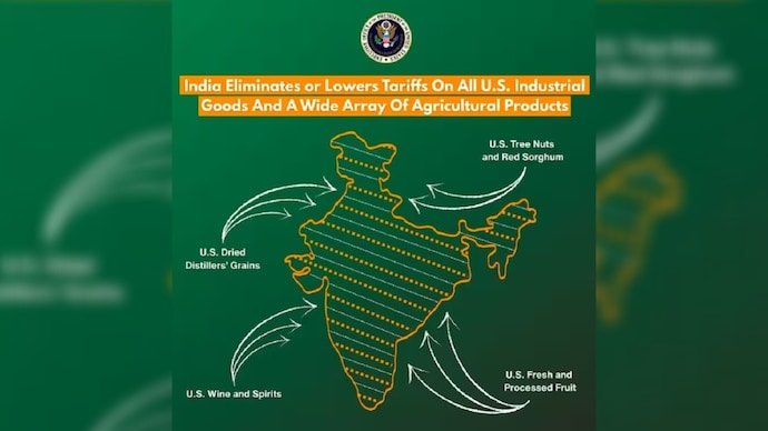
The map in question accompanied information about a newly agreed trade framework between the United States and India. While the framework focuses on reducing tariffs and expanding economic cooperation between the two countries, the cartographic representation of disputed regions became the focal point of controversy.
Specifically, the map appeared to include:
- The entirety of Jammu and Kashmir within India’s borders
- Pakistan-administered Kashmir as Indian territory
- Aksai Chin — a region administered by china but claimed by India — within India’s boundaries
Given the longstanding geopolitical sensitivities surrounding Kashmir, even symbolic depictions can carry significant diplomatic implications. Maps, while not legally determinative, often reflect policy nuances and can signal political positioning — intentional or otherwise.
Understanding the Disputed Territories
Aksai Chin
Aksai Chin is a high-altitude plateau administered by China but claimed by India as part of the Union Territory of Ladakh. The region has been a major flashpoint in the broader India–China boundary dispute and was a central factor in the 1962 Sino-Indian conflict. Its depiction on official maps is closely scrutinized by all parties involved.
Pakistan-Administered Kashmir (PoK)
Pakistan-administered Kashmir, which includes areas such as Azad Jammu and Kashmir and Gilgit-Baltistan, has been under Pakistan’s control since the first Indo-Pak war in 1947–48. India refers to the territory as Pakistan-occupied Kashmir (PoK), asserting that it is an integral part of India. The Line of Control (LoC) currently separates Indian-administered and Pakistan-administered areas.
The status of Jammu and Kashmir has remained a central and unresolved issue between India and Pakistan for over seven decades, with periodic escalations and diplomatic efforts shaping the regional security landscape.
US Policy and Cartographic Sensitivities
Historically, the United States has maintained a careful diplomatic balance regarding Kashmir, encouraging bilateral dialogue between India and Pakistan while avoiding overt endorsements of territorial claims in official cartography. For this reason, deviations in map depictions — even in social media posts — can quickly become politically charged.
While the removal of the USTR post appears to have resolved the immediate diplomatic concern, the episode underscores how sensitive geopolitical boundaries remain in South Asia. In an era where official communications are rapidly amplified online, even routine trade announcements can take on broader strategic significance.
Trade Framework Overshadowed by Diplomatic Dispute
The map controversy unfolded against the backdrop of a significant US–India trade development aimed at reducing tariff barriers and expanding access between two of the world’s largest economies. With India’s economy valued at over $3 trillion and growing strategic ties between Washington and New Delhi, the trade framework represents a key pillar of bilateral cooperation.
However, as speculation mounted over whether the map was an oversight or a subtle geopolitical signal, the USTR’s office opted to remove the post entirely, effectively closing the immediate controversy without issuing a detailed clarification.
Conclusion: A Reminder of Regional Fragility
The incident serves as a reminder that in South Asia, cartography is never merely technical — it is deeply political. For Pakistan, the depiction of Jammu and Kashmir remains a matter of diplomatic vigilance. For the United States, balancing strategic partnerships with regional stability requires careful messaging.
As geopolitical alignments evolve and economic partnerships deepen, even digital maps can shape narratives, trigger diplomatic responses, and reflect the complex realities of one of the world’s most sensitive regions.
For breaking news and live news updates, like us on Facebook or follow us on Twitter and Instagram. Read more on Latest World on thefoxdaily.com.


COMMENTS 0