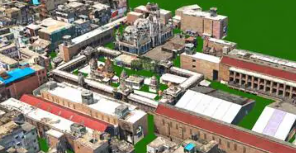
Indian cities are becoming more complex to manage as population growth, flooding, informal settlements, redevelopment, heritage conservation and infrastructure pressure reshape the urban landscape. A new generation of digital twin technology is emerging as a powerful way to understand these changes with far greater precision.
Varanasi offers one of the clearest examples. Alongside the physical city of temples, ghats and densely packed streets, officials now have a 160-sq-km digital replica created using LiDAR, aerial and drone imagery, ground-level scans and 360-degree mapping. Unlike a conventional map, the model can be connected with real-world data, updated over time and used to examine possible scenarios before decisions are implemented.
The potential is significant. Officials can identify areas vulnerable to flooding, estimate the properties affected by road widening, detect possible encroachments and identify changes in the use of buildings. Similar digital twin projects are emerging in Mumbai, Kochi, Kanpur and Pune, suggesting that 3D urban mapping could become an important layer of India’s future city-management infrastructure.
What Is a Digital Twin of a City?
A city digital twin is a detailed digital representation of a real urban environment. It can include buildings, roads, utilities, terrain, public infrastructure and other physical features, while also connecting those elements with relevant data.
The key difference from a traditional map is that a digital twin is designed to represent the city as it exists and changes. Instead of simply showing where a road or building is located, the model can help authorities examine how changes to that environment could affect people, infrastructure and services.
- LiDAR: Captures highly detailed three-dimensional information about terrain and structures.
- Drone and aerial imagery: Helps map large areas and difficult-to-reach locations.
- 360-degree street scans: Provide ground-level information about streets, buildings and public spaces.
- GIS data: Connects spatial information with administrative and infrastructure datasets.
- Regular updates: Allow authorities to monitor how the physical city changes over time.
This combination can turn Urban Planning from a largely static exercise into a more dynamic process based on current information.
Varanasi Digital Twin: From Flood Management to Property Taxes
Varanasi is already using its digital twin for practical urban-management problems. One important application is flood preparedness.
Officials can use the model to identify locations likely to be affected when water levels rise, map potential waterlogging zones and identify houses that could face flooding. This can help authorities position emergency resources and prepare response plans before conditions become critical.
The technology is also being used to assess infrastructure projects. For road-widening projects, the model can help estimate the amount of built-up area that may need to be removed and identify properties likely to be affected. This gives authorities a clearer spatial picture before construction begins.
Property Tax Could Become a Major Use Case
One of the most financially important applications is property-tax assessment. Urban buildings can change rapidly, with residential properties being converted into hotels, offices, shops or other commercial uses without corresponding changes in records.
A regularly updated three-dimensional model can help authorities identify these changes by comparing current spatial information with older records. Such information could support revised property assessments and potentially increase municipal revenue.
This is particularly important for Indian municipalities, many of which struggle to maintain accurate property databases and collect sufficient local revenue for infrastructure and public services.
Dharavi Digital Twin: Creating a Baseline for Redevelopment
Mumbai’s Dharavi presents a different but equally important use case. The densely populated area contains homes, workshops, commercial establishments, narrow lanes and utilities layered together over decades.
For a redevelopment project of this complexity, one of the first challenges is establishing an accurate picture of what physically exists. A detailed digital twin can provide that spatial baseline.
Mapping combining LiDAR, drones and ground surveys can document structures, lanes, utilities and other features. Such information can then be referenced throughout the redevelopment process.
The potential benefit is greater transparency. When the physical environment is documented systematically, authorities and planners have a common reference point for understanding existing conditions and evaluating changes.
This does not automatically eliminate disputes, however. A digital record can improve evidence and transparency, but questions involving ownership, occupancy, eligibility and rehabilitation still require legal and institutional processes.
Why Digital Twins Matter for Indian Cities
India’s urban planning system often faces a fundamental information problem: the city described in official plans may not fully match the city that exists on the ground.
Buildings are expanded, land uses change, informal settlements grow, roads become congested and drainage patterns evolve. Traditional surveys may not capture these changes quickly enough.
A digital twin can narrow this gap by creating a detailed and updateable representation of the physical environment.
| Urban challenge | Potential digital twin application |
|---|---|
| Flooding | Flood-risk mapping, waterlogging prediction and emergency planning |
| Redevelopment | Existing-condition mapping and rehabilitation planning |
| Property taxation | Detection of building and land-use changes |
| Road projects | Impact assessment and identification of affected properties |
| Traffic | Simulation of transport flows and infrastructure changes |
| Heritage | High-resolution documentation of historic structures |
| Climate resilience | Scenario modelling for rainfall, heat and other risks |
Digital Twin Is an Information Revolution, Not a Governance Shortcut
The biggest misconception about digital twins is that better technology automatically produces better governance.
A highly accurate model can reveal an encroachment, an unassessed building extension or a drainage problem. But identifying a problem is only the first step. Authorities still need the institutional capacity, budget, legal authority and political willingness to act on that information.
This distinction is crucial for Indian cities. A digital twin can tell officials what is happening, but it cannot by itself change administrative incentives or resolve conflicts between agencies.
In other words, digital twins can make a city more legible, but institutions must determine what happens after that information becomes visible.
Singapore, Helsinki and the Global Digital Twin Lesson
International experience provides useful lessons for India.
Singapore: Test Before Building
Singapore’s Virtual Singapore model demonstrates how a data-rich 3D environment can be used to examine possible interventions before implementing them in the physical city. Planners can explore potential effects involving traffic, population and environmental conditions.
The important principle is simple: instead of asking what happened after a project was built, authorities can increasingly ask “What could happen if we build it?” beforehand.
Helsinki: Residents as Participants
Helsinki’s Kalasatama digital twin provides another lesson. Digital models can be used not only by government departments but also to help residents understand proposed developments.
This introduces a participatory dimension that could become particularly valuable in large redevelopment projects, where residents often want to understand how changes will affect their neighbourhoods.
United Kingdom: Standards and Interoperability
The UK’s National Digital Twin Programme highlights another requirement: different digital models must be able to communicate with one another under appropriate standards and governance arrangements.
Without interoperability, individual departments may simply create separate digital islands, reproducing the same fragmentation found in traditional urban administration.
India’s Biggest Challenge: Who Owns the Digital Twin?
Creating the model is only the beginning. The more difficult question is who will operate, update and govern it.
Indian cities are often managed by multiple organisations, including municipal corporations, development authorities, water agencies, electricity departments, transport bodies and other government institutions. Each organisation may maintain its own datasets.
If these datasets conflict, the digital twin can reproduce the same inconsistencies rather than solving them.
A strong city-level framework therefore needs clear responsibility for data standards, maintenance, access and updates.
Why Interoperability Matters
Imagine a city where the municipal corporation has one building database, the electricity utility has another and the water authority has a third. If all three datasets describe the same property differently, a digital twin cannot automatically determine which version is correct.
This makes common standards and institutional coordination essential.
An effective system would ideally establish:
- A clear authority responsible for the digital twin.
- Common data standards across departments.
- Rules for sharing information between agencies.
- Regular funding for data updates.
- Cybersecurity and privacy safeguards.
- Processes for correcting inaccurate information.
- A mechanism for citizens to challenge decisions based on digital records.
Why Keeping the Digital Twin Updated Is Critical
A digital twin is only useful if it remains reasonably representative of the real city.
Urban environments change continuously. New floors are added, roads are redesigned, buildings are demolished, businesses open and close, drainage systems change and informal development expands.
A model created once and then left untouched could quickly become outdated.
This means cities must treat digital twins as continuing public infrastructure rather than one-time technology projects. Budgets must account for future aerial surveys, drone flights, ground verification, software maintenance, data storage and staff training.
Heritage Conservation Could Benefit From 3D Mapping
Digital twins are not limited to modern infrastructure. They can also become powerful tools for heritage preservation.
High-resolution LiDAR and photogrammetry can document historic structures whose architectural details may be difficult to measure manually. This is particularly useful in areas containing narrow streets, crowded facades and intricate buildings.
For heritage authorities, a detailed digital record can serve as a reference for conservation, restoration and damage assessment.
The technology can also reduce the need for repeated manual measurement of fragile or difficult-to-access structures.
The Data Infrastructure Gap
High-quality mapping produces enormous quantities of data. That creates another challenge for Indian urban local bodies.
Having sophisticated equipment is not enough if officials lack the software infrastructure, computing resources and training required to use the resulting datasets.
This creates a potential technology paradox: cities can possess highly detailed digital information while still lacking the institutional capacity to turn that information into decisions.
Training therefore needs to be treated as part of the digital twin investment rather than an optional addition.
Privacy, Data Protection and the “Umpire’s Call” Problem
The more detailed a digital twin becomes, the more important questions about data protection become.
Urban models can potentially contain information connected to properties, infrastructure and people. Authorities therefore need clear rules about what information can be collected, who can access it and how sensitive information should be protected.
There is also an important question of accountability. What happens if a digital model says a property is unauthorised, a building has changed use or a particular structure falls within a redevelopment boundary?
Citizens need a mechanism to challenge inaccurate information.
This is similar to the principle of uncertainty in sports decision-making: technology can provide powerful evidence, but there must still be a transparent institutional process for reviewing contested outcomes.
India’s National Digital Twin Ambition
The National Geospatial Policy, notified in 2022, provides a broader policy framework for expanding geospatial capabilities in India. The country’s long-term vision includes developing digital representations of major urban centres.
Projects in Varanasi, Dharavi, Kochi, Kanpur and Pune show how that ambition can translate into city-level applications.
However, the eventual success of a national digital twin ecosystem will depend on more than mapping technology. Data standards, interoperability, institutional ownership, privacy safeguards, financing and continuous maintenance will determine whether these models remain useful over time.
What Cities Should Prioritise First
Building a complete digital replica of an entire city and connecting every possible dataset at once may be expensive and difficult. A phased strategy could be more practical.
Cities could begin with problems where accurate spatial information can produce measurable benefits.
- Flood management: Map vulnerable areas and drainage networks.
- Property taxation: Detect changes in built-up area and land use.
- Traffic management: Model congestion and test transport interventions.
- Redevelopment: Establish reliable existing-condition baselines.
- Heritage: Digitally preserve vulnerable historic structures.
Once these applications demonstrate value, additional datasets and departments can be integrated.
Digital Twins Could Change the Way Cities Plan for the Future
Traditional urban master plans often attempt to predict what a city might look like decades from now. But cities rarely develop exactly according to those assumptions.
Digital twins offer a different approach. Instead of relying only on a fixed long-term vision, planners can create multiple scenarios and compare their possible consequences.
For example, a city could examine how a neighbourhood might respond to heavier rainfall, higher temperatures, population growth or increased transport demand. The objective is not to predict the future perfectly but to understand how different choices could perform under different conditions.
This could make urban planning more adaptive and evidence-driven.
What Digital Twins Mean for Indian Urban Governance
The real significance of India’s digital twin projects is not the visual appeal of a three-dimensional city model. Their value lies in creating a shared and continuously updated information layer for decision-making.
For Varanasi, that means better flood planning, infrastructure impact assessment and potentially stronger property-tax administration. For Dharavi, it means creating a detailed spatial baseline for an exceptionally complex redevelopment process. For other cities, the priorities may be traffic, climate resilience, heritage or infrastructure management.
But technology will not eliminate the difficult parts of urban governance. Land disputes, political decisions, administrative coordination, financing and public participation will remain human and institutional challenges.
Conclusion: The City of the Future May Need a Digital Twin
India’s cities are changing too quickly for static maps and infrequently updated plans to provide the complete picture required for modern urban management. Digital twins can help bridge the gap between official records and conditions on the ground.
The technology can make hidden changes visible, allow infrastructure projects to be tested digitally, improve disaster preparedness and provide a stronger evidence base for redevelopment and taxation.
Yet the next stage is more difficult than creating the model. Cities must decide who owns it, who updates it, how agencies share data, how citizens can challenge inaccuracies and how governments will finance the system over many years.
If those institutional foundations are built alongside the technology, digital twins could evolve from sophisticated mapping projects into essential urban infrastructure. The ultimate transformation would not simply be that Indian cities become digitally visible. It would be that governments become better equipped to understand, test and manage the cities they are responsible for.
For breaking news and live news updates, like us on Facebook or follow us on Twitter and Instagram. Read more on Latest Business on thefoxdaily.com.




COMMENTS 0