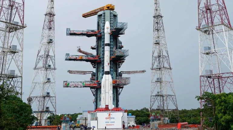
The Indian Space Research Organisation (ISRO) is preparing to launch its GSLV-F18 rocket carrying the NVS-03 navigation satellite from Sriharikota, Andhra Pradesh, on Friday, October 30, 2026. The scheduled liftoff is at 11:51 PM IST from the Second Launch Pad at the Satish Dhawan Space Centre, marking the 20th flight of India’s Geosynchronous Satellite Launch Vehicle.
The mission is an important step in strengthening India’s independent satellite navigation network, the Navigation with Indian Constellation (NavIC). NVS-03 is the third satellite in the next-generation navigation series and is designed to support continuity of positioning, navigation and timing services across India and a region extending approximately 1,500 kilometres beyond the country’s boundaries.
The satellite carries an indigenous atomic clock alongside procured atomic clocks. It will also introduce the L1 navigation signal in addition to the existing L5 and S-band signals, expanding the system’s capabilities and improving compatibility with a wider range of navigation receivers.
ISRO has commenced the 24-hour countdown, which began at 11:51 PM IST on Thursday, October 29. The agency has scheduled its live broadcast to begin at 11:20 PM IST on Friday, around 31 minutes before the planned launch.
ISRO GSLV-F18 Launch 2026: Key Details
- Mission: GSLV-F18/NVS-03
- Launch date: Friday, October 30, 2026
- Scheduled liftoff: 11:51 PM IST
- Live broadcast: From 11:20 PM IST
- Launch site: Second Launch Pad, Satish Dhawan Space Centre, Sriharikota, Andhra Pradesh
- Rocket: Geosynchronous Satellite Launch Vehicle (GSLV)
- Payload: NVS-03 navigation satellite
- Satellite mass: Approximately 2,232 kg
- Target orbit: Geosynchronous Transfer Orbit (GTO)
- Mission significance: Strengthening India’s NavIC navigation system
How to Watch ISRO GSLV-F18 Launch Live
ISRO has scheduled the live coverage of the GSLV-F18/NVS-03 mission to begin at 11:20 PM IST on October 30. The broadcast will provide viewers with coverage of the launch preparations, final countdown and rocket liftoff.
Viewers can follow the mission through ISRO’s official website and YouTube channel. The agency’s official livestream is scheduled to start approximately half an hour before the 11:51 PM launch time.
Watching the official broadcast will allow viewers to follow the launch sequence and hear mission updates from ISRO’s coverage. As with any space launch, the scheduled time remains subject to operational and technical conditions, so viewers should follow official announcements for any changes.
What Is the GSLV-F18 Mission?
GSLV-F18 is the 20th flight of India’s Geosynchronous Satellite Launch Vehicle. The rocket is designed to carry heavy communication, navigation and other satellites into geosynchronous transfer orbits, from where spacecraft can use their onboard propulsion systems to reach their intended operational positions.
The launch vehicle stands approximately 50 metres tall and has a lift-off mass of around 420 tonnes. It uses a three-stage propulsion system combining solid, liquid and cryogenic technologies.
The first stage provides the initial thrust needed to lift the rocket away from the launch pad. The subsequent stages continue accelerating the vehicle and guide it towards the targeted orbit. Its indigenous cryogenic upper stage is particularly important for missions requiring the placement of heavier satellites into high-energy orbits.
For the GSLV-F18 mission, the rocket will carry the 2,232-kg NVS-03 satellite and attempt to inject it into a Geosynchronous Transfer Orbit. Successful injection will be an important milestone, but it will not mean that the satellite immediately becomes operational. Additional orbital manoeuvres and system checks will be required.
What Is NVS-03 and Why Is ISRO Launching It?
NVS-03 is the third satellite in India’s next-generation navigation satellite series. The NVS programme is intended to maintain and improve the services provided by the Indian Regional Navigation Satellite System, which is now known as NavIC.
NavIC is India’s independent regional satellite navigation system. It provides positioning, navigation and timing information to users across the Indian mainland and an area extending approximately 1,500 kilometres beyond the country’s geopolitical boundary.
Like other satellite navigation systems, NavIC relies on signals transmitted by satellites in orbit. Receivers on the ground, in aircraft, ships and other platforms use signals from multiple satellites to calculate their location and obtain precise timing information.
The NVS-03 mission is important because it adds another next-generation satellite to the constellation. Its deployment is intended to support continuity of navigation services and strengthen the availability of India’s regional positioning capabilities.
How Does India’s NavIC Navigation System Work?
NavIC, previously known as the Indian Regional Navigation Satellite System (IRNSS), was developed to give India an independent satellite-based positioning and timing capability.
The system works through a constellation of navigation satellites and a network of ground infrastructure. Satellites transmit signals containing information about their positions and precise time. A compatible receiver uses signals from multiple satellites to estimate its distance from each one and calculate its location.
This process is known as satellite-based positioning. The receiver compares the time a signal was transmitted with the time it was received. Since radio signals travel at a known speed, the time difference helps determine the distance between the receiver and each satellite.
By combining measurements from several satellites, a receiver can calculate its position and obtain accurate timing information. The ground segment supports the system by monitoring satellites, maintaining navigation data and helping ensure the accuracy and reliability of the service.
Why India Needs Its Own Navigation System
Satellite navigation has become essential to modern infrastructure. It supports road navigation, aviation, maritime operations, surveying, emergency response, logistics, telecommunications and several other applications.
India’s own navigation system provides a regional alternative to relying entirely on foreign satellite navigation services such as the United States’ Global Positioning System (GPS). An independent system gives the country greater control over the infrastructure supporting navigation and timing services within its intended coverage area.
NavIC is also relevant to strategic applications where reliable positioning and timing information can be important. Its development strengthens India’s domestic capabilities in satellite navigation technology and supports the wider space programme.
What New Features Will NVS-03 Bring to NavIC?
NVS-03 includes two important features highlighted by ISRO: an indigenous atomic clock and the addition of the L1 navigation signal alongside the existing L5 and S-band signals.
1. Indigenous Atomic Clock for Precise Timing
Precise timekeeping is fundamental to satellite navigation. Navigation satellites continuously transmit signals containing timing information, and even small timing errors can affect the accuracy of distance calculations performed by receivers.
Atomic clocks provide highly precise time references by using the stable natural frequencies associated with atoms. Unlike ordinary clocks, which depend on mechanical movement or electronic oscillations that can drift, atomic clocks use atomic transitions to maintain extremely accurate timing.
NVS-03 carries an indigenous atomic clock alongside procured atomic clocks. The inclusion of domestically developed timing technology is significant for India’s navigation programme because it supports the development of local expertise and reduces dependence on externally sourced components.
The indigenous clock is part of a broader effort to strengthen India’s capabilities in satellite navigation and precision timing. Its performance will be assessed as part of the satellite’s commissioning and operational checks after launch.
2. Addition of the L1 Navigation Signal
Another important feature of NVS-03 is the inclusion of the L1 signal in addition to the existing L5 and S-band signals used by NavIC.
Navigation signals operate on different radio frequencies, and receiver compatibility depends partly on which signals a device is designed to process. The addition of L1 is expected to make NavIC more compatible with a wider range of modern navigation receivers.
The L1 frequency is widely used by satellite navigation systems and is supported by many navigation chipsets and consumer devices. Its inclusion could therefore help expand the range of equipment capable of using NavIC signals.
However, the availability of the signal does not automatically mean that every smartphone or navigation device will support the new capability. Actual compatibility will depend on the receiver hardware, software and implementation of the relevant navigation standards.
3. Support for Navigation Services Across India and Beyond
ISRO has designed NVS-03 to support navigation coverage across India’s landmass and a region extending approximately 1,500 kilometres around the country’s geopolitical boundary.
The satellite is intended to contribute to the continuity of NavIC services. Its contribution will depend on successful deployment, orbital positioning, commissioning and integration with the wider satellite constellation.
Why Is the NVS-03 Launch Important for India’s NavIC Network?
NavIC’s development has faced challenges involving the operational life of earlier satellites and technical problems affecting some spacecraft. These issues have made the addition of replacement and next-generation satellites important for maintaining the system’s intended services.
The deployment of NVS-03 is expected to increase the number of operational satellites available to the constellation. Reports on the mission have highlighted that its successful placement could help restore the basic satellite availability required for standalone regional positioning and timing services.
The next-generation NVS programme is also intended to improve the system’s capabilities through upgraded satellite technology. NVS-03 follows the earlier NVS-01 and NVS-02 missions, while future satellites, including NVS-04 and NVS-05, are expected to contribute to the wider modernisation effort.
For India, the mission is therefore not simply about launching another satellite. It is part of a longer programme to maintain an independent navigation infrastructure and improve the reliability and compatibility of its services.
What Happens to NVS-03 After the Rocket Reaches Orbit?
After GSLV-F18 releases NVS-03 into its targeted Geosynchronous Transfer Orbit, the satellite will begin a series of operations to reach its designated orbital position.
A GTO is an elliptical orbit used as a transfer path towards higher operational orbits. It has a relatively low point, known as perigee, and a much higher point, known as apogee. The satellite uses its onboard propulsion system to perform orbit-raising manoeuvres and adjust its trajectory.
According to the mission details, the targeted transfer orbit has a planned perigee of approximately 170 kilometres and an apogee of around 37,023 kilometres, with an inclination of 20.75 degrees.
Once the satellite separates from the launch vehicle, mission controllers will monitor its condition and trajectory. The spacecraft will then perform the necessary manoeuvres to reach its designated operational position.
Orbital Manoeuvres and Satellite Commissioning
Orbital manoeuvres are essential because the initial orbit achieved by the launch vehicle is not necessarily the final orbit required for regular navigation operations.
Mission controllers use tracking information and onboard telemetry to determine whether the spacecraft is following the expected trajectory. The satellite’s propulsion system can then be used to make adjustments and raise or modify its orbit.
After reaching the intended position, NVS-03 will undergo a series of in-orbit checks. Engineers will examine its power systems, communication equipment, navigation payload, atomic clocks and other onboard components.
The satellite will become part of the operational NavIC network only after the required checks and commissioning activities are completed. The time needed for this process depends on the spacecraft’s orbital progress and the performance of its systems.
How Will ISRO Scientists Track NVS-03 After Launch?
ISRO will monitor NVS-03 through ground-based tracking, telemetry and command systems. These facilities allow mission controllers to receive information from the satellite, assess its health and send commands when required.
Telemetry is the process through which a spacecraft transmits information about its operating condition to ground stations. The data can include details about electrical power, temperature, communication systems, propulsion and other onboard equipment.
Tracking systems help scientists determine the satellite’s position and movement. By analysing the signals received from the spacecraft, ground teams can estimate its orbit and check whether it is following the planned trajectory.
Command systems allow authorised controllers to communicate with the satellite and issue instructions for operations such as orbital adjustments and configuration changes.
These activities will be particularly important after NVS-03 enters its transfer orbit. Scientists will need to confirm that the satellite has separated successfully, that its systems are functioning and that its subsequent manoeuvres are progressing as planned.
What Are the Major Challenges After Liftoff?
Although the rocket’s launch is the most visible part of the mission, several important stages follow liftoff. A successful launch vehicle performance must be followed by accurate satellite separation, orbital manoeuvres and successful commissioning.
Successful Satellite Separation
The first major requirement is for GSLV-F18 to place NVS-03 into the intended transfer orbit and release it safely. Any significant deviation from the planned trajectory could affect the satellite’s ability to reach its designated operational position.
Reliable Propulsion and Orbit Raising
After separation, the satellite must use its propulsion system to perform the required orbital adjustments. These manoeuvres need to be carefully planned and monitored because they determine whether the spacecraft can reach its intended position.
Performance of the Atomic Clocks
The satellite’s atomic clocks must operate reliably because accurate timing is essential to navigation signals. Engineers will need to assess their performance during the commissioning process and verify that the navigation payload is functioning as expected.
Integration With the Existing NavIC Constellation
NVS-03 must also be integrated into the wider navigation network. Its contribution will depend on how its signals and operational capabilities work alongside the other satellites and the ground segment.
These stages explain why a successful liftoff is an important milestone but not the final measure of mission success. The satellite must complete its orbital and operational checks before it can contribute fully to NavIC services.
What Comes Next for India’s Navigation Satellite Programme?
NVS-03 is part of a broader effort to modernise and maintain India’s regional navigation system. The next-generation NVS series is designed to improve continuity and introduce updated capabilities that support a wider range of navigation applications.
Future missions, including NVS-04 and NVS-05, are expected to play a role in strengthening the constellation. Their deployment will be important for building a more resilient satellite network and supporting the long-term availability of NavIC services.
The programme also reflects India’s wider ambitions in space technology. Developing navigation satellites, precision clocks, ground infrastructure and associated receiver technologies requires expertise across several areas of engineering and scientific research.
As satellite navigation becomes increasingly important to transportation, communications, industrial operations and digital infrastructure, maintaining a reliable domestic system has strategic and economic value.
ISRO GSLV-F18/NVS-03 Launch: What to Expect Tonight
The GSLV-F18/NVS-03 mission is scheduled to lift off at 11:51 PM IST on October 30 from Sriharikota. ISRO’s live coverage is scheduled to begin at 11:20 PM, allowing viewers to follow the final preparations and countdown.
The mission will mark the 20th flight of India’s GSLV and carry a 2,232-kg navigation satellite into Geosynchronous Transfer Orbit. NVS-03 will add an indigenous atomic clock and the L1 navigation signal to the capabilities of India’s next-generation NavIC satellite series.
If the launch and subsequent orbital operations proceed as planned, the satellite will strengthen India’s regional navigation infrastructure and support the continuity of positioning and timing services. Its performance will also provide an important indication of progress in the country’s next-generation navigation satellite programme.
For India, the mission represents another step towards maintaining an independent satellite navigation system. The immediate focus will be on the rocket’s performance, successful satellite deployment and the series of operations required to bring NVS-03 into service.
For breaking news and live news updates, like us on Facebook or follow us on Twitter and Instagram. Read more on Latest Technology on thefoxdaily.com.






COMMENTS 0