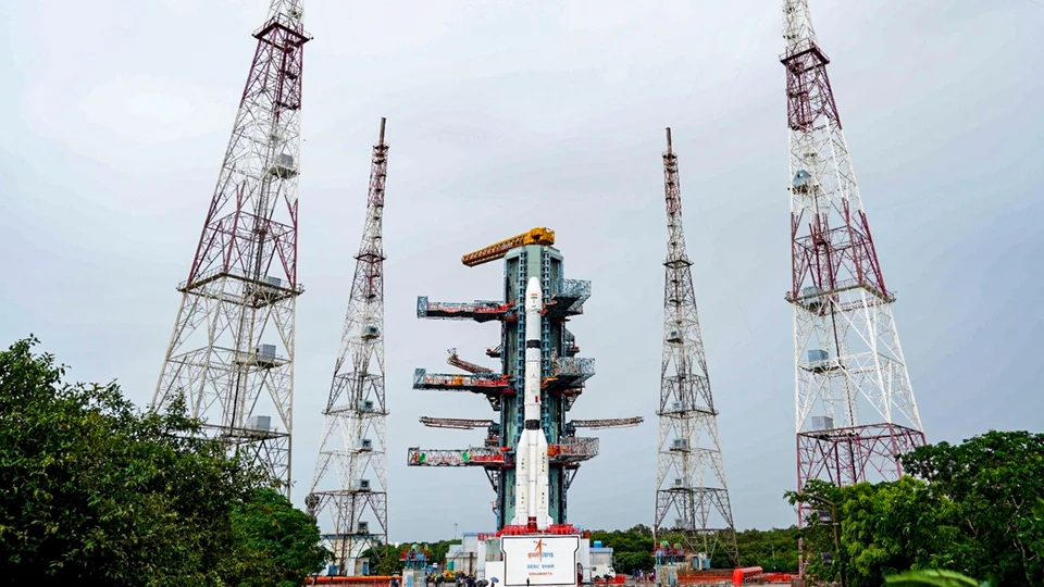
Prime Minister Narendra Modi on Saturday congratulated scientists and engineers of the Indian Space Research Organisation (ISRO) following the successful launch of the GSLV-F18 rocket carrying the next-generation navigation satellite NVS-03. He said the mission would strengthen India’s indigenous Satellite Navigation system, NavIC, and advance the country’s efforts towards self-reliance in critical technologies.
The satellite was launched aboard the GSLV-F18 rocket from the Satish Dhawan Space Centre in Sriharikota on Friday, October 30, 2026. After its launch, NVS-03 successfully separated from the launch vehicle and was placed into its intended Geosynchronous Transfer Orbit (GTO), marking another milestone in India’s space and navigation programmes.
In a post on X, Modi praised the dedication and technical capabilities of India’s space scientists, highlighting the satellite’s enhanced navigation features and its potential contribution to services used by people across the country.
“Congratulations to our scientists and engineers at ISRO on the successful launch of GSLV-F18 carrying NVS-03. This mission marks an important step in strengthening NavIC, our indigenous satellite navigation system. Equipped with enhanced capabilities, NVS-03 will further our pursuit of self-reliance in critical technologies and support navigation services that benefit our people. The dedication and ingenuity of our space scientists continue to make our nation proud,” Modi wrote.
The launch is significant for India’s efforts to maintain an independent satellite navigation capability. NVS-03 belongs to ISRO’s next-generation navigation satellite series, which is intended to ensure continuity and improve the performance of services provided through the Indian Regional Navigation Satellite System (IRNSS), popularly known as NavIC.
GSLV-F18 Successfully Places NVS-03 Satellite into Orbit
ISRO launched the GSLV-F18 mission at 11:51 PM IST on October 30, 2026, from the Satish Dhawan Space Centre in Sriharikota, Andhra Pradesh. The rocket carried the 2,250-kg NVS-03 navigation satellite as its payload.
Following a successful flight, the satellite separated from the launch vehicle and entered its intended Geosynchronous Transfer Orbit. This initial orbit is part of the process through which the satellite will move towards its operational position and begin the next stages of deployment.
GSLV-F18 was the 20th flight of India’s Geosynchronous Satellite Launch Vehicle (GSLV). The mission also demonstrated ISRO’s ability to carry out another launch within a relatively short period after its previous GSLV mission.
ISRO Chairman V Narayanan said the satellite had been precisely injected into its intended elliptical orbit. He described the launch as an important development for the country’s navigation programme and congratulated the scientists, engineers, industrial partners and academic institutions involved in the mission.
The successful deployment of NVS-03 is particularly important because India’s navigation system requires a functioning constellation of satellites to provide reliable positioning, navigation and timing services. The new satellite is expected to strengthen the existing network and support its planned expansion.
What Is NVS-03 and Why Is It Important?
NVS-03 is the third satellite in ISRO’s next-generation Navigation with Indian Constellation (NavIC) satellite series. The series is designed to improve the capabilities of India’s regional navigation system and maintain the continuity of services as earlier-generation satellites approach the end of their operational lives.
NavIC was developed to provide India with an independent satellite-based navigation capability rather than relying entirely on foreign systems. It supports positioning, navigation and timing services for civilian, commercial and strategic applications.
Satellite navigation technology is used in a wide range of activities, including vehicle tracking, maritime navigation, aviation-related applications, disaster management, location-based services and timing synchronisation. These capabilities are increasingly important for transport networks, communication infrastructure and public services.
NVS-03 incorporates several technological improvements intended to strengthen the performance of the navigation constellation. One of its important features is the inclusion of an indigenous atomic clock, alongside procured atomic clocks.
It also introduces the L1 navigation signal in addition to the existing L5 and S-band signals. This addition is expected to expand the system’s compatibility and improve its usefulness for a wider range of applications.
The satellite’s successful launch therefore represents more than the addition of another spacecraft to India’s orbital infrastructure. It is part of a broader effort to improve the reliability, coverage and technological independence of the country’s navigation services.
Indigenous Atomic Clock Strengthens NavIC Capabilities
One of the most significant technologies carried by NVS-03 is its indigenous atomic clock. Atomic clocks are essential components of satellite navigation systems because they provide highly precise time measurements used to calculate the position of receivers on Earth.
Satellite navigation works by measuring the time taken for signals to travel from satellites to receivers. Even very small timing errors can produce significant inaccuracies in calculated positions. Highly accurate clocks are therefore necessary to maintain reliable navigation services.
Developing an atomic clock domestically is also important from a strategic perspective. It reduces dependence on imported technologies for a critical component of the navigation system and strengthens India’s ability to maintain and upgrade its satellite infrastructure.
ISRO Chairman V Narayanan said two indigenous atomic clocks were already functioning in orbit, while a third had been deployed aboard NVS-03.
The inclusion of these clocks reflects India’s progress in developing specialised technologies required for independent satellite navigation. It also supports the country’s wider objective of increasing domestic capabilities in areas where technological dependence could create strategic vulnerabilities.
However, the performance of a navigation satellite depends on several systems working together. Accurate clocks, reliable signal transmission, ground infrastructure and a properly functioning satellite constellation are all necessary for delivering consistent services.
New L1 Signal to Expand NavIC’s Navigation Services
NVS-03 also carries an L1 navigation signal, adding another frequency to the existing L5 and S-band signals used by NavIC.
The addition is important because navigation receivers use satellite signals transmitted at specific frequencies to determine their positions. Supporting additional signals can improve compatibility with different types of receivers and expand the potential applications of the system.
The L1 frequency is widely used by global satellite navigation systems and compatible devices. Its inclusion in the next-generation NavIC satellites is intended to make the Indian system more accessible to a broader range of users and technologies.
For civilian applications, improved compatibility could support the wider use of NavIC in navigation-enabled devices and services. These include applications involving transportation, location tracking, mapping and other activities that depend on accurate positioning information.
The addition of the L1 signal is part of ISRO’s effort to modernise NavIC and make the system more suitable for evolving technological requirements.
Nevertheless, wider public adoption will depend on more than satellite capabilities. Receiver compatibility, device integration, service availability and the completion of the required satellite constellation will also influence how extensively NavIC can be used.
NavIC Coverage: India and 1,500 Kilometres Beyond Its Borders
India’s Regional Navigation Satellite System has been designed to provide coverage over the country’s landmass and an area extending approximately 1,500 kilometres beyond its geopolitical boundary.
This coverage objective gives NavIC a regional focus while allowing it to support users in areas beyond India’s borders. The system is intended to provide independent positioning, navigation and timing services across the defined coverage region.
Explaining the programme after the launch, ISRO Chairman V Narayanan said seven satellites were envisaged for providing navigation services across India and the surrounding region.
“India has got a navigation programme. And as per the programme, we are supposed to provide navigation services for India plus 1,500 kilometres from the Indian border, called the Regional Navigation Service. For that, seven satellites are supposed to be in orbit,” Narayanan said.
The planned constellation is important because navigation services rely on signals from multiple satellites. A sufficient number of operational satellites is required to provide reliable positioning coverage across the intended region.
The NVS series is intended to maintain and strengthen the existing constellation through newer satellites equipped with updated technology. Its development is therefore closely linked to the long-term continuity of India’s regional navigation services.
Successful Launch Restores NavIC to Minimum Operational Configuration
ISRO Chairman V Narayanan said the successful launch of NVS-03 had restored the NavIC constellation to its minimum operational configuration of four satellites.
This is an important development for the navigation programme because the availability of operational satellites directly affects the system’s ability to provide services. Maintaining the minimum required constellation helps support continuity while ISRO works towards completing the broader satellite network.
Narayanan also described the navigation constellation as a strategic national asset. Independent access to positioning, navigation and timing information is important for civilian applications as well as government and strategic requirements.
Navigation services can support emergency response, transport operations, maritime activities, infrastructure management and other applications that require accurate location and time information.
For India, maintaining an independent system also provides greater control over a critical technology platform. It reduces the country’s reliance on external satellite navigation services and gives domestic agencies the ability to develop applications suited to national requirements.
However, restoring the minimum operational configuration should not be confused with completing the entire planned constellation. ISRO’s stated objective remains to develop the seven-satellite system needed to provide the intended regional navigation services.
ISRO Completes GSLV Missions With a 56-Day Turnaround
Another significant aspect of the GSLV-F18 mission was the interval between successive launches of the Geosynchronous Satellite Launch Vehicle.
Narayanan highlighted that the turnaround time between the two GSLV missions was 56 days, describing it as the shortest interval achieved so far for the launch vehicle.
A shorter turnaround is an important operational achievement because preparing a launch vehicle involves several stages, including manufacturing and assembly, system integration, testing, safety checks and coordination between different technical teams.
Reducing the time between missions can help improve launch operations and support a more regular schedule for deploying satellites. This is particularly relevant as India continues to expand its requirements for communication, navigation, Earth observation and scientific missions.
The achievement also reflects the contribution of ISRO’s industrial partners and academic institutions, which support different parts of India’s space programme through manufacturing, research and technical development.
For the GSLV programme, maintaining reliability while increasing operational efficiency remains important as the launch vehicle continues to support missions involving heavier satellites and complex orbital requirements.
How NavIC Differs From GPS
NavIC is India’s regional satellite navigation system, while the Global Positioning System (GPS) is operated by the United States and provides global coverage. Both systems use satellites to deliver positioning, navigation and timing information, but their coverage objectives and operational structures differ.
GPS is designed to provide navigation services around the world. NavIC, on the other hand, focuses on India and a surrounding region extending approximately 1,500 kilometres beyond the country’s borders.
India developed NavIC to ensure that it has an independent navigation capability for applications that depend on accurate positioning and timing. The system can support civilian users, transport services, infrastructure operators and strategic requirements.
The availability of an indigenous system gives India greater control over an important part of its technological infrastructure. It also allows the country to develop services and applications around its own navigation requirements.
NavIC is not intended simply to replace every global navigation system. Instead, it provides an additional regional capability that can strengthen India’s technological independence and support applications within its coverage area.
When Will NavIC Be Integrated More Widely Into Mobile Systems?
Wider integration of NavIC into mobile devices is one of the potential benefits of strengthening the satellite constellation and expanding signal compatibility.
Modern smartphones and navigation devices can support signals from multiple satellite navigation systems. This allows receivers to use available satellite information to calculate positions and provide location-based services.
However, broader integration of NavIC into mobile systems depends on several factors, including the availability of operational satellites, compatible receiver hardware, software support and adoption by device manufacturers.
Narayanan said the entire planned constellation would need to be completed before the navigation service could be integrated with mobile systems for wider public use.
This indicates that the successful launch of NVS-03 is an important step, but additional work remains before the programme reaches its broader objectives. Completing the constellation and ensuring compatibility with devices will be important for expanding public access to the system.
As the next-generation satellites become operational, NavIC could support a wider range of applications in transportation, mapping, emergency services and location-based technology.
What the GSLV-F18 Mission Means for India’s Space Programme
The successful GSLV-F18 launch strengthens two important areas of India’s space programme: independent satellite navigation and the development of critical space technologies within the country.
NavIC is a strategic asset because positioning and timing services support essential civilian and government activities. Maintaining the system through next-generation satellites helps reduce dependence on external navigation infrastructure.
The mission also demonstrates the importance of developing specialised components domestically. The indigenous atomic clock onboard NVS-03 is an example of how Indian institutions are working to build technologies that are essential for advanced satellite systems.
At the same time, the launch vehicle’s 56-day turnaround between successive GSLV missions highlights progress in operational efficiency. Such improvements can support India’s plans to carry out more missions while maintaining the reliability required for complex satellite deployments.
Prime Minister Narendra Modi’s congratulatory message reflects the wider national significance attached to the mission. His remarks highlighted the contribution of ISRO scientists and engineers to strengthening India’s technological capabilities and providing services that benefit the public.
With NVS-03 successfully placed into its intended transfer orbit, ISRO has taken another step towards maintaining and expanding NavIC. The next phase will involve completing the required satellite constellation, establishing the satellite’s operational capabilities and supporting wider adoption of India’s indigenous navigation services.
For breaking news and live news updates, like us on Facebook or follow us on Twitter and Instagram. Read more on Latest India on thefoxdaily.com.






COMMENTS 0