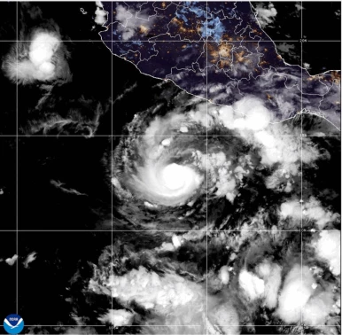
Hurricane Trudy brought heavy rain and strong winds to parts of southwestern and west-central Mexico early on Sunday, October 18, as it continued moving northwest parallel to the country’s Pacific coast. The storm maintained its strength during the morning, prompting warnings about flooding, landslides and dangerous waves in vulnerable coastal areas.
According to the US National Hurricane Center (NHC), Trudy was located approximately 150 miles (240 kilometres) west of Manzanillo, Mexico, with maximum sustained winds of 105 miles per hour (165 kilometres per hour).
The hurricane was moving northwest at around 10 mph (17 kph). Forecasters expected it to remain near Mexico’s Pacific coastline through Sunday evening before beginning to weaken rapidly overnight.
Although the storm was forecast to lose strength, authorities warned that heavy rainfall and hazardous coastal conditions could continue to threaten communities across the affected regions.
Hurricane Trudy Forecast to Weaken Overnight
The National Hurricane Center said Trudy was expected to maintain relatively stable intensity during the morning before experiencing a significant decline in strength later in the day.
“Little change in strength is expected this morning, but rapid weakening is forecast to begin by tonight,” the NHC said.
The hurricane was forecast to continue tracking near the Pacific coast through Sunday evening. Its projected path would then take it south of Baja California Sur on Monday and Tuesday as it weakened.
The forecast offered some indication that the most intense phase of the storm could be relatively short-lived. However, a weakening hurricane can still produce dangerous rainfall, flooding and coastal hazards, particularly in areas exposed to strong onshore winds.
Residents in potentially affected areas were therefore facing risks beyond the storm’s maximum wind speed. Heavy rain falling over a short period can overwhelm drainage systems, trigger flash floods and destabilise hillsides, while strong waves and storm surges can threaten coastal communities.
Heavy Rainfall Raises Flooding and Mudslide Risks
One of the main concerns surrounding Hurricane Trudy was the volume of rainfall expected across parts of Michoacan, Colima and Jalisco. The NHC forecast rainfall totals of between four and eight inches (10 to 20 centimetres) in affected areas, with isolated locations potentially receiving around 12 inches.
Such rainfall can create dangerous conditions, particularly in regions with steep terrain, where saturated soil may increase the likelihood of landslides and mudslides.
Flash flooding is another significant concern when intense rainfall occurs over a relatively short period. Water levels in rivers and streams can rise quickly, while roads, low-lying neighbourhoods and other vulnerable locations may become difficult or dangerous to access.
The risk can be especially serious in mountainous areas, where runoff moves rapidly downhill and can carry mud, rocks and debris. Communities located near slopes or waterways may face additional dangers if rainfall persists or becomes more intense than expected.
Although the forecast indicated that Trudy would weaken overnight, the anticipated rainfall totals highlighted the potential for hazardous conditions to continue even as wind speeds declined.
Storm Surge and Dangerous Waves Threaten Pacific Coast
The National Hurricane Center also reiterated warnings about dangerous storm surges and damaging waves along sections of Mexico’s Pacific coast exposed to onshore winds.
Storm surge occurs when strong winds push seawater towards the shoreline, causing water levels to rise above normal tidal conditions. When combined with large waves, it can increase the risk of coastal flooding and damage in exposed areas.
These conditions can also make beaches, coastal roads and other shoreline locations dangerous. Powerful waves and strong currents may pose risks even where rainfall is limited or the storm’s winds have begun to weaken.
Coastal communities were therefore urged to take the warnings seriously while the hurricane remained near the region. The potential combination of heavy rainfall, storm surge and damaging waves created several overlapping hazards across parts of the Pacific coastline.
Mexico Monitors Multiple Weather Threats
Hurricane Trudy’s movement along Mexico’s Pacific coast placed several southwestern and west-central areas under the threat of severe weather. The projected rainfall across Michoacan, Colima and Jalisco was a particular concern because of the potential for life-threatening flooding and mudslides.
The storm’s forecast track also meant that coastal hazards could persist while Trudy moved northwest and gradually weakened. Weather conditions can vary considerably from one location to another, depending on the storm’s movement, local terrain and the distribution of rainfall.
The NHC’s forecast called for Trudy to remain near the coast through Sunday evening before weakening rapidly overnight. It was then expected to move south of Baja California Sur on Monday and Tuesday.
Storm’s Weakening Does Not Eliminate Immediate Risks
Hurricane Trudy’s anticipated weakening could reduce the threat from its strongest winds, but forecasters continued to highlight the dangers associated with heavy rainfall, flooding, mudslides and coastal waves.
The projected rainfall of four to eight inches, with isolated totals of around 12 inches, raised concerns for communities in areas vulnerable to rapid runoff and unstable slopes. Meanwhile, storm surge and damaging waves remained potential hazards along exposed sections of the Pacific coast.
The storm’s progress and changing intensity were expected to remain important factors in assessing the risks through Monday and Tuesday. Even as Trudy weakened, its rainfall and coastal effects could continue to affect parts of Mexico’s southwestern and west-central regions.
Residents in threatened areas were advised to follow official weather alerts and local emergency guidance, particularly where flooding, landslides or dangerous coastal conditions were possible.
For breaking news and live news updates, like us on Facebook or follow us on Twitter and Instagram. Read more on Latest Business on thefoxdaily.com.





COMMENTS 0