What would happen if rising sea levels gradually flooded the coastal districts, ports and industrial facilities of Los Angeles? Scientists have explored that question using an unusual research environment: Los Santos, the fictional city in Grand Theft Auto V (GTA V). By transforming the familiar virtual landscape into a climate-change simulation, researchers have shown how rising seas and storm surges could threaten coastal infrastructure over the coming centuries.
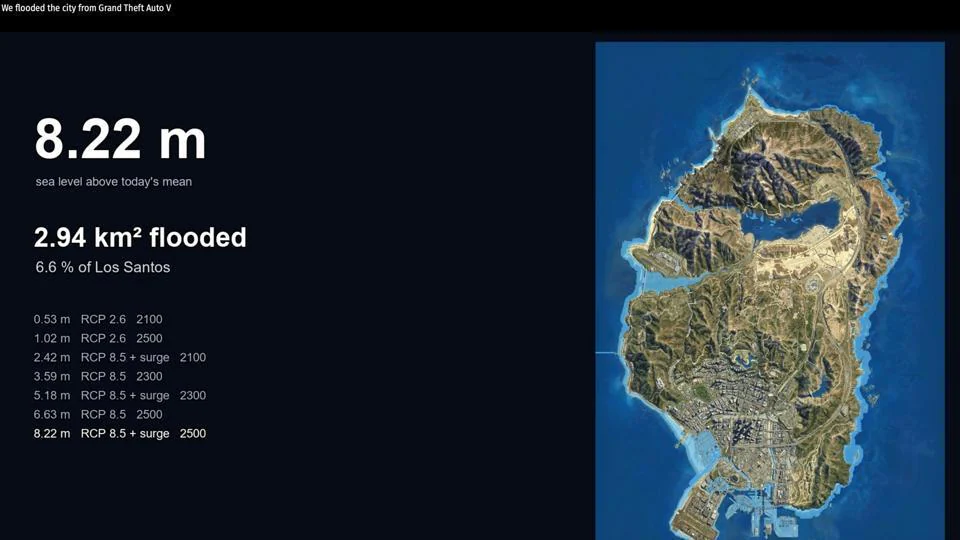
The study, conducted by Paul Nörenberg of the University of Potsdam and Hugues Lantuit of the Alfred Wegener Institute, used the detailed digital environment of GTA V to model future flooding. The simulated water reaches Vespucci’s canals first, before threatening the Port of South Los Santos, gasworks and wastewater treatment infrastructure.
The findings are particularly interesting because Los Santos closely resembles real-world Los Angeles. When researchers compared the game’s flood patterns with actual maps and existing flood studies, they found that many of the same coastal districts and infrastructure areas appeared vulnerable in both environments.
Beyond its scientific findings, the research points to a possible new role for video games in climate communication. Instead of presenting sea-level projections only through technical maps and conventional visualisations, scientists could use familiar virtual environments to help people experience the potential consequences of environmental change.
How Scientists Turned GTA V’s Los Santos Into a Flood Simulation
GTA V is designed primarily for entertainment, but its detailed recreation of Los Angeles offers an unusual opportunity for geographical research. Its fictional city, Los Santos, includes recognisable coastal landscapes, neighbourhoods, roads, industrial facilities and landmarks that closely resemble features of the real American city.
According to lead author Paul Nörenberg, modern video games have advanced graphically to the point where they can reproduce real-world locations with remarkable accuracy. He described Los Santos as a near-exact replica of Los Angeles, including its neighbourhoods, famous landmarks and urban and coastal features.
However, using the game for scientific modelling required more than simply raising the water level inside the virtual world. Rockstar Games does not publicly release the raw terrain data needed for this kind of research. The scientists therefore had to reconstruct and calibrate the game’s geography using information available outside the original game development system.
They began with a fan-created three-dimensional model of the GTA V map. The model was aligned with real-world coordinates using 11 control points, allowing the virtual landscape to be positioned geographically rather than treated as an isolated game environment.
The researchers then used 31 shoreline points to establish the sea-level reference. They also checked the coastline by flying an in-game helicopter along it, helping them compare the virtual geography with the intended coastal boundaries. Mount Chiliad, one of the game’s most recognisable geographical features, was used as a reference for calibrating elevation.
Once the virtual terrain had been positioned and calibrated, the researchers could apply projected sea levels and storm-surge conditions to examine which parts of Los Santos would become submerged.
IPCC Climate Scenarios Reveal Different Flooding Futures
The researchers used two Representative Concentration Pathway (RCP) scenarios from the Intergovernmental Panel on Climate Change‘s Fifth Assessment Report. These pathways represent different possible climate futures, depending on the level of greenhouse gas emissions and mitigation efforts.
RCP 8.5 represents a high-emissions pathway, while RCP 2.6 represents a substantially stronger mitigation scenario. Applying both to the virtual city allowed the researchers to examine how different climate trajectories could affect the same coastal landscape.
The simulations covered three future time horizons: 2100, 2300 and 2500. Each scenario also incorporated a 1.59-metre storm surge, based on the highest storm surge recorded in Los Angeles.
This combination allowed the researchers to examine not only the gradual rise in sea levels but also the additional flooding pressure created when unusually high coastal water levels occur.
RCP 8.5: Greater Long-Term Exposure for Coastal Infrastructure
Under the RCP 8.5 scenario, the study projects that combined sea levels and storm-surge conditions could reach 5.18 metres by 2300. The model estimates that approximately 5.1% of the mapped land area would be inundated under this scenario.
The projected impact becomes more extensive over the longer term. For the 2500 scenario, the supplied research reports a projected sea level of 8.22 metres and estimates that 6.5% of the mapped land area could be flooded.
The consequences extend beyond the loss of coastal land. The simulation places important infrastructure, including the port, wastewater facilities and coastal energy installations, at risk. These facilities are essential to the functioning of a modern city, making their exposure particularly significant.
Ports support the movement of goods, industrial facilities provide energy-related services, and wastewater infrastructure plays a central role in sanitation and public health. Flooding that disrupts these systems could have consequences far beyond the immediate coastal areas.
RCP 2.6: Stronger Climate Mitigation Limits the Damage
The lower-emissions RCP 2.6 scenario produces a considerably smaller flood footprint. By 2300, the model estimates that approximately 2.2% of the mapped land area would be inundated when storm surges are included.
Importantly, the simulation does not show major infrastructure being affected under this scenario. The contrast with RCP 8.5 demonstrates how different climate pathways can produce substantially different outcomes for the same coastal city.
The comparison is one of the study’s most important messages. Sea-level rise is not presented as a single unavoidable future with identical consequences under every scenario. The scale of exposure changes depending on the emissions pathway and the extent of climate mitigation.
Vespucci, Chumash and the Port of South Los Santos Face Flood Risks
One of the most striking aspects of the research is how closely the simulated flood patterns resemble the vulnerabilities identified in real Los Angeles.
In GTA V, Vespucci is a coastal district with canals and a landscape inspired by Venice Beach. The simulation shows this area among the first places affected by rising water. Its geography makes it a useful virtual example of how low-lying coastal neighbourhoods can face increasing flood exposure.
Chumash, another coastal area in Los Santos, is similarly vulnerable in the simulation. Its real-world counterpart is comparable to Malibu, where coastal development and proximity to the ocean create exposure to rising sea levels and storm surges.
The Port of South Los Santos also emerges as a major concern. Its vulnerability mirrors that of the real Port of Los Angeles, where flooding could threaten infrastructure supporting shipping and industrial activity.
The researchers overlaid their virtual simulation results onto real maps and existing flood studies for Los Angeles. They found that the same broad districts identified as vulnerable in the game also appeared among the exposed areas in real-world assessments.
This similarity suggests that Rockstar Games’ detailed recreation of Los Angeles has preserved important aspects of the city’s coastal geography. Although the game was never designed as a scientific model, its virtual landscape has inadvertently reproduced several real-world vulnerabilities.
Why GTA V Could Make Climate Change More Personal
The researchers are not presenting the game as a replacement for established climate models. Instead, they see its potential as a communication tool that can help audiences understand scientific projections in a more immediate way.
Traditional flood maps and climate models are essential for researchers, planners and policymakers. However, they can be difficult for people without technical backgrounds to interpret. A coloured map showing projected inundation may communicate the extent of flooding, but it does not necessarily create a personal connection with the places being affected.
GTA V offers a different experience because millions of players have spent time exploring Los Santos. They know its roads, beaches, neighbourhoods and landmarks. Watching familiar locations disappear beneath rising water could make the consequences of climate change easier to understand emotionally.
Nörenberg argues that when a virtual landscape that players have personally explored begins to change, they can engage with climate impacts on a more emotional level. This familiarity may bridge a gap that conventional maps and scientific visualisations sometimes struggle to overcome.
The approach also benefits from the game’s enormous audience. Rockstar Games has said that GTA V has sold more than 225 million copies over the past decade, making it one of the best-selling video games in history. That gives the researchers access to a familiar digital environment recognised by a large international community.
Instead of asking audiences to imagine an unfamiliar future city, the simulation shows what could happen to a place they may already know. This could make climate-related risks more accessible, particularly to younger audiences and people who regularly interact with open-world games.
Why the GTA V Flood Model Is Not a Perfect Scientific Prediction
Despite its potential, the research comes with important limitations. A commercial video game is designed to create an engaging and believable experience, not to function as a highly detailed scientific representation of coastal systems.
The terrain in GTA V is a digital approximation of real geography. Even where the city’s layout resembles Los Angeles, the game environment does not reproduce every natural feature, elevation difference or physical process with the precision required for detailed flood-risk planning.
The simulation also uses a static inundation model. This means it shows which areas could be covered by water under specified conditions, rather than reproducing the full complexity of how flooding develops and changes over time.
Real coastal environments are shaped by several interacting processes. Coastal erosion can gradually alter shorelines, drainage systems influence how water moves through urban areas, and changing weather conditions can affect the severity and timing of floods. A simplified static model cannot fully capture these dynamics.
The researchers have also cautioned that the far-future projections for 2300 and 2500 are the weakest parts of the scenario set. Such long-term horizons involve substantial uncertainty, and the results should not be interpreted as precise predictions of what Los Angeles will look like on those dates.
The study therefore recommends that this approach be used as a template for geoscience communication, provided that its limitations are clearly explained to every audience. The distinction is important: the model can help people visualise possible outcomes, but it should not be treated as a substitute for detailed coastal engineering assessments or official flood-risk projections.
Could Video Game Maps Become Useful Tools for Climate Research?
The GTA V experiment raises a broader question about the scientific value of increasingly realistic virtual environments. Video game developers invest substantial resources in building detailed digital landscapes, including roads, buildings, coastlines and complex urban environments.
Although these worlds are created for entertainment, some of their geographical features may also be useful for scientific communication and exploratory research. A carefully calibrated virtual city could help researchers demonstrate how environmental changes might affect familiar locations.
Open-world games are particularly interesting because they allow audiences to move through large environments rather than view them from a fixed perspective. A flooded street, inaccessible port or submerged coastal neighbourhood can be experienced as part of a connected urban landscape.
However, the usefulness of such environments will depend on the quality of their underlying geographical data and the ability to communicate uncertainty. A visually realistic game world is not automatically a scientifically accurate digital twin. Researchers must still establish coordinates, calibrate elevations and compare results against reliable real-world information.
The Los Santos study demonstrates how those steps can turn a commercial game environment into a useful visualisation platform. It does not prove that video games can replace professional climate modelling, but it shows that virtual worlds may have a role beyond entertainment.
GTA VI Launch Puts the Research in the Spotlight
The timing of the research also brings it into the spotlight alongside the launch of GTA VI. The new release has renewed attention on Rockstar’s ability to create detailed fictional environments inspired by real places.
While the study focuses on GTA V rather than the newer game, its wider significance extends to the growing realism of commercial virtual worlds. As game developers build increasingly detailed cities, researchers may find new opportunities to explore how familiar environments can communicate complex real-world issues.
The central lesson from the Los Santos experiment is not that a video game can predict the exact future of Los Angeles. It is that a familiar virtual city can make an otherwise abstract climate scenario easier to see, explore and understand.
In the simulation, the sea does not arrive because of a mission, a criminal chase or a player-controlled disaster. It advances through the city under different climate scenarios, exposing the places and infrastructure that could face increasing pressure from rising water. By turning that process into an interactive visual reference, scientists have found an unconventional way to bring the long-term risks of sea-level rise closer to everyday experience.
For breaking news and live news updates, like us on Facebook or follow us on Twitter and Instagram. Read more on Latest India on thefoxdaily.com.





COMMENTS 0