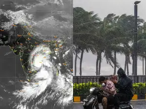
The India Meteorological Department (IMD) has warned that another cyclonic system developing over the Bay of Bengal could approach the Andhra Pradesh coast around November 3, just days after Cyclone Arnab affected the eastern coast. The developing system is expected to be weaker than Arnab, although its movement and intensity will remain under close observation.
The latest forecast comes as the southern peninsula enters the northeast monsoon season, a period when weather systems over the Bay of Bengal can bring heavy rainfall to coastal and southern parts of India. The IMD has also issued a broader seasonal outlook indicating below-normal rainfall over parts of the southern peninsula, alongside above-normal temperatures across much of the country.
New Cyclonic System Developing Over the Bay of Bengal
According to the IMD’s October 31 update, a weather system over the southeast Bay of Bengal was likely to intensify into a depression and strengthen further into a cyclonic storm. The system is expected to move west-northwestwards towards the west-central Bay of Bengal and approach the Andhra Pradesh coast.
The forecast suggests that the system could reach the coastal region around November 2 or November 3. However, the precise track, intensity and possibility of landfall will depend on how the system develops over the coming days.
The developing system originated as a low-pressure area over the South Andaman Sea and adjoining North Andaman Sea. It subsequently became a well-marked low-pressure area over the southeast Bay of Bengal and surrounding areas.
The IMD’s forecast indicates that the system could become a cyclonic storm within the next 24 hours from its October 31 update. It is expected to move towards the west-central Bay of Bengal, bringing the Andhra Pradesh coast under monitoring for possible weather impacts.
Why the New Storm Is Expected to Be Weaker Than Cyclone Arnab
The developing system is expected to be less intense than Cyclone Arnab, which crossed the Andhra Pradesh and Yanam coasts on October 28 as a very severe cyclonic storm. Arnab brought strong winds and heavy rainfall to several areas, causing damage to infrastructure, crops and homes.
The IMD’s latest assessment indicates that the new system is likely to be weaker than Arnab. This distinction is important because the strength of a cyclone influences the potential severity of its winds, rainfall and coastal impacts.
However, a weaker classification does not mean that the system will be harmless. Even a comparatively less intense cyclonic storm can produce heavy rainfall, rough seas and strong winds, particularly along exposed coastal areas.
The IMD has not indicated that the new system will necessarily make landfall on November 3. Its projected approach towards the coast should therefore be distinguished from a confirmed landfall forecast.
Possible Wind Speeds Could Reach 100 Kmph
IMD Director General Mrutyunjay Mohapatra said the possible cyclonic storm could bring sustained wind speeds of 80 to 90 kmph, with occasional gusts reaching 100 kmph. The system may make landfall along the Andhra Pradesh coast on the morning of November 3, according to the forecast reported on October 31. :chatgpt-content-reference{index=”0″}
For comparison, Cyclone Arnab crossed the Andhra Pradesh coast on October 28 with reported wind speeds of around 150 kmph. The difference in projected wind strength indicates that the new system is expected to be less intense, although its eventual impact will depend on its development and track.
The IMD said the depression was located approximately 330 km west-southwest of Sri Vijayapuram in the Andaman Islands and 300 km west-northwest of Car Nicobar at 11.30 am on October 31. It was forecast to move west-northwestwards and intensify into a deep depression before developing into a cyclonic storm. :chatgpt-content-reference{index=”1″}
Heavy Rainfall and Rough Sea Conditions Under Watch
The approaching system could influence weather conditions across parts of the eastern and southern peninsula. The IMD is monitoring its movement and is expected to issue further updates as its intensity and direction become clearer.
Light to moderate rainfall or thundershowers have been forecast in a few districts of Odisha. The earlier system, Cyclone Arnab, had caused extensive rainfall and flooding in parts of Andhra Pradesh and Odisha, making preparedness important as another disturbance develops over the Bay of Bengal. :chatgpt-content-reference{index=”2″}
Coastal communities, fishermen and local authorities will need to follow official weather bulletins, particularly if the system strengthens and approaches the coast. Forecasts of wind speed and rainfall can change as a cyclone develops, so the latest district-level warnings will be important for decisions on fishing, transport and outdoor activities.
South Peninsula May Receive Below-Normal Seasonal Rainfall
Alongside the immediate cyclone forecast, the broader seasonal outlook points to below-normal rainfall over much of the southern peninsula during the October-December period. This is significant because the northeast monsoon supplies a substantial share of annual rainfall to Tamil Nadu, coastal Andhra Pradesh and other parts of southern India.
The South Asian Climate Outlook Forum, coordinated through the World Meteorological Organization, has indicated that below-normal rainfall is likely over much of central and southern peninsular South Asia during October-December 2026. At the same time, normal to above-normal maximum and minimum temperatures are expected across most of the wider region. :chatgpt-content-reference{index=”3″}
A seasonal rainfall outlook describes the expected overall pattern across several months. It does not rule out short periods of intense rainfall. A cyclone or other low-pressure system can still produce heavy downpours in particular districts even when the seasonal total is forecast to remain below normal.
Above-Normal Temperatures Forecast Across Much of India
The wider temperature outlook also indicates that much of India could experience above-normal temperatures. Some areas in the northwest may be exceptions to this pattern, according to the seasonal forecast information.
Temperature and rainfall forecasts are based on large-scale atmospheric and oceanic conditions. Their purpose is to identify broad seasonal tendencies rather than predict the exact weather for an individual day or location. Local conditions can vary considerably, especially when a developing weather system affects a particular region.
Strong El Niño Conditions Could Influence Weather Through March
El Niño is another major climate factor being monitored by international and Indian weather agencies. It involves warmer-than-average sea surface temperatures across parts of the central and eastern equatorial Pacific Ocean and can influence atmospheric circulation, rainfall patterns and temperatures in different parts of the world.
The World Meteorological Organization’s October 2026 seasonal update indicated that El Niño conditions were expected to strengthen further during the October-December period, with the warming trend forecast to peak around December. The organisation also highlighted the development of a positive Indian Ocean Dipole, another ocean-atmosphere factor that can influence rainfall over the region. :chatgpt-content-reference{index=”4″}
India’s Ministry of Earth Sciences had also stated in a July 2026 parliamentary reply that El Niño conditions were expected to intensify during the October-December period and could reach the very strong category. The ministry cautioned that the precise effects on India would depend on the evolution of oceanic and atmospheric conditions, rather than El Niño alone. :chatgpt-content-reference{index=”5″}
These climate conditions could remain relevant to weather patterns into the early months of 2027. However, their influence on India’s rainfall and temperature distribution will depend on how the Pacific and Indian Ocean conditions evolve. Seasonal forecasts are updated as new observations and climate-model projections become available.
How El Niño and the Northeast Monsoon Are Connected
The northeast monsoon is particularly important for southern India, where it contributes significantly to rainfall between October and December. El Niño can influence the strength and distribution of monsoon rainfall, but its effects are not identical in every year.
The Indian Ocean Dipole, atmospheric circulation, ocean temperatures and the movement of individual weather systems can also affect rainfall. This means that a strong El Niño does not automatically result in deficient rainfall in every southern state or district.
The possibility of a cyclonic storm approaching Andhra Pradesh illustrates the difference between seasonal and short-term forecasts. A season may be expected to receive below-normal rainfall overall, while a single storm can still bring intense rain and strong winds over a limited period.
What Residents Along the Andhra Coast Should Watch
With the new system expected to approach the Andhra Pradesh coast around November 2-3, residents and authorities will be watching subsequent IMD bulletins for changes in the projected track, wind strength and rainfall distribution.
- Storm intensity: The possible system is forecast to develop into a cyclonic storm, with winds of 80-90 kmph and gusts up to 100 kmph.
- Expected approach: The system is forecast to reach the west-central Bay of Bengal near the Andhra Pradesh coast around November 2, with a possible coastal crossing on November 3.
- Comparison with Arnab: The new system is expected to be weaker than Cyclone Arnab, which brought winds of around 150 kmph at landfall.
- Further warnings: Changes in the system’s movement or intensity could lead to revised rainfall, wind and coastal advisories.
Residents in potentially affected areas should rely on official IMD forecasts and instructions issued by local administrations. Fishermen should follow marine warnings and avoid venturing into areas where authorities have advised against fishing.
Back-to-Back Storms Put Eastern Coast Weather Under Focus
The development of another cyclonic system so soon after Cyclone Arnab has placed the Bay of Bengal under renewed weather scrutiny. The new depression is expected to strengthen as it moves towards the west-central Bay, with the Andhra Pradesh coast facing a possible approach around November 3.
Although the IMD expects the system to be weaker than Arnab, its projected winds and potential rainfall mean that it remains important to monitor. At the same time, the seasonal outlook points to below-normal rainfall over much of the southern peninsula and above-normal temperatures across large parts of India.
The coming days will clarify whether the system follows the forecast track and how much of the coast could be affected. Until then, the IMD’s regular updates will remain the key source of information on the storm’s development and potential impacts.
For breaking news and live news updates, like us on Facebook or follow us on Twitter and Instagram. Read more on Latest India on thefoxdaily.com.





COMMENTS 0