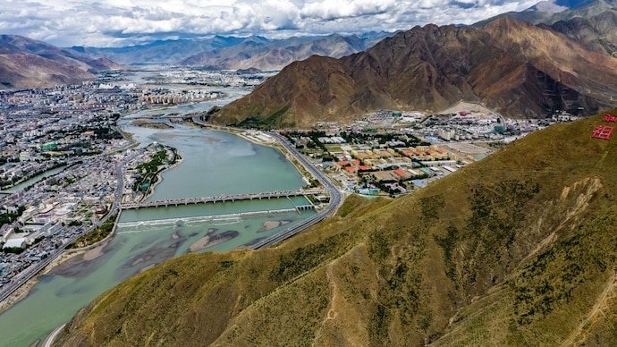
The catastrophic floods that swept across parts of Nepal and Tibet have brought renewed attention to one of the most consequential infrastructure projects in the Himalayas: China’s planned 60,000-megawatt Medog Hydropower Station on the Yarlung Tsangpo River.
The disaster itself was not caused by the Medog project. Current evidence points to a sudden ice-and-rock collapse or glacial event that unleashed a destructive surge of water and debris through mountain valleys along the Nepal-Tibet border. But the scale of the devastation has revived a separate question that has concerned Indian officials and researchers for years: what happens when an enormous hydropower project is built in one of the world’s most earthquake-prone mountain regions?
The Medog project, also known as the Motuo Hydropower Station, is being developed on the lower reaches of the Yarlung Tsangpo in Tibet, close to India’s Arunachal Pradesh. China authorised the project in 2024, and construction began in July 2025. Once completed, the project is expected to become the world’s largest hydropower facility by installed capacity.
Its location is what makes the project especially sensitive. The Yarlung Tsangpo eventually enters India as the Siang and then becomes the Brahmaputra, a river system that supports millions of people, agriculture, fisheries and ecosystems across Arunachal Pradesh and Assam before flowing into Bangladesh.
The Nepal disaster has exposed the Himalayas’ cascading risks
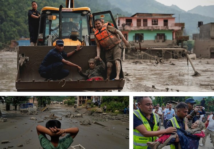
The latest disaster began with a sudden release of enormous amounts of water, ice, rock and debris in the Himalayan border region. Nepal has reported more than 150 deaths, while hundreds of people remain missing. Tibet’s Gyirong County was also badly affected, with Chinese authorities reporting deaths and hundreds of missing people as Rescue Operations continued.
The exact sequence that produced the flood has been investigated since the event occurred. Initial reports considered whether an earthquake had triggered an avalanche. Later assessments pointed toward a glacial ice-and-rock collapse as the immediate trigger, with the resulting material blocking and then releasing water into the river system.
That distinction matters when discussing the Medog Dam. There is currently no evidence that the Medog project caused the Nepal disaster. The flood occurred in a different river system and was associated with a natural high-altitude event.
What the disaster does demonstrate, however, is the extraordinary speed with which hazards can cascade through the Himalayan environment. A collapse high in the mountains can trigger flooding downstream, destroy infrastructure and leave communities with little time to respond.
That is precisely why the safety of very large dams in active seismic zones attracts such intense scrutiny.
Why the Medog Dam is attracting attention
China’s Medog project is designed to harness the enormous elevation drop of the Yarlung Tsangpo as the river makes a dramatic turn around the Namcha Barwa massif before entering India.
The project is expected to have an installed capacity of approximately 60,000 MW. That would make it several times larger in generating capacity than the Three Gorges project and potentially the largest hydropower development in the world.
The scale is partly explained by the extraordinary geography. The Yarlung Tsangpo descends sharply through a deep Himalayan gorge, creating enormous hydropower potential.
China plans to develop multiple hydropower facilities along this section of the river. The engineering challenge is equally enormous: construction must take place in steep, remote terrain where geological instability, seismic activity and difficult access are major considerations.
Construction officially began in July 2025, and available project information has placed the eventual completion of the development in the early 2030s. But the project remains years away from full operation, meaning its final design, construction progress and safety performance will continue to attract scrutiny.
A Chinese-linked geological study raised a new warning
One of the most important developments in the debate came from research published in 2026 by geologists affiliated with China’s state geological survey.
The study, reported by the South China Morning Post and other outlets, identified the Paizhen Fault beneath or directly associated with the Medog project area. The finding has attracted attention because an active fault in the vicinity of a major hydropower installation raises questions about seismic design, geological stability and long-term infrastructure resilience.
The significance of an active fault should not be exaggerated. The presence of a fault does not mean that a dam will inevitably fail, nor does it establish that the project is unsafe. Large dams can be engineered to withstand substantial seismic forces, and detailed geological and structural assessments are part of major hydropower projects.
But the finding reinforces why the Medog project cannot be evaluated simply on the basis of its electricity-generating potential.
The relevant question is whether the project’s engineering, foundations, tunnels, reservoirs and associated infrastructure have been designed with the full range of geological hazards in the region adequately accounted for.
The Himalayan seismic problem is bigger than one dam
The Himalayas were created by the continuing collision of the Indian and Eurasian tectonic plates. The resulting tectonic environment makes the region highly earthquake-prone.
That geological reality has implications for virtually every major infrastructure project in the mountains.
For a conventional road or building, an earthquake can cause structural damage. For a massive dam or reservoir, the consequences of a major seismic event could be considerably more complicated because earthquakes can interact with slopes, tunnels, foundations, reservoirs and downstream river channels.
A strong earthquake could also trigger landslides or rockfalls into a river or reservoir. Such secondary events can become as important as the earthquake itself when assessing flood risk.
The recent Nepal disaster provides a vivid example of this broader principle, even though it was not caused by the Medog Dam. The event showed how an apparently local high-altitude collapse can rapidly become a downstream disaster.
Could the Medog Dam become a “water bomb”?
Some Indian and international commentators have described the Medog project as a potential “water bomb” because of its size and location.
The phrase is politically powerful, but it should be treated as a warning metaphor rather than a technical conclusion.
A dam does not become a catastrophic threat simply because it is large. Its actual risk depends on engineering standards, geological conditions, reservoir characteristics, operating procedures, monitoring systems and the consequences of different failure scenarios.
At the same time, the potential consequences of a serious accident at a huge upstream facility would warrant careful examination because the river flows directly toward densely populated areas downstream.
For India, the concern is therefore not simply whether China could deliberately release a huge volume of water. It is whether an extreme event involving the dam, its associated infrastructure or the surrounding terrain could produce unusually large changes in downstream river flows.
Why India is worried about the Brahmaputra
India is a lower-riparian country on the Brahmaputra system. The river originates in Tibet as the Yarlung Tsangpo before entering Arunachal Pradesh, where it is known as the Siang, and then flowing through Assam as the Brahmaputra.
China controls the river’s upper reaches, giving Beijing a position that naturally concerns New Delhi.
However, an important point is often overlooked in discussions of the river. China does not control the majority of the Brahmaputra’s eventual water volume. Once the river enters India, it receives substantial flows from tributaries, particularly during the South Asian monsoon.
That means a Chinese project cannot simply be assumed to have the ability to “turn off” the Brahmaputra for India.
The more realistic concern is changes in the timing and variability of flows.
Reservoir operations can theoretically alter when water is stored and when it is released. During dry periods, upstream storage could affect downstream availability. During periods of intense rainfall, releases from reservoirs would need to be carefully managed alongside natural flows.
These possibilities are why India has repeatedly sought greater transparency and hydrological information from China concerning projects on transboundary rivers.
The real problem may be information, not just water
One of India’s biggest strategic concerns is the absence of a comprehensive water-sharing framework with China comparable to some international river treaties elsewhere in Asia.
Hydrological information can be crucial during extreme events. If a sudden landslide, glacial collapse or other disaster occurs upstream, downstream authorities need timely information to warn communities.
The recent Nepal-Tibet disaster has reinforced that point.
Nepalese officials and commentators have raised questions about the availability and speed of warnings before the devastating flood. But those concerns should not automatically be extended into an accusation that China deliberately withheld a warning without verified evidence establishing what information was available, when it became available and what authorities knew at the time.
The lesson for India is nevertheless clear: real-time information can be as important as physical control over water.
Early warnings about extreme flows, landslides, glacial collapses and possible dam-related emergencies can give downstream communities valuable time to move away from rivers and vulnerable infrastructure.
India is pursuing its own Siang mega-project
India has responded to China’s upstream hydropower expansion partly by advancing its own massive project in Arunachal Pradesh.
The proposed Siang Upper Multipurpose Project has an estimated capacity of about 11,000 MW to 11,200 MW, depending on the project configuration under consideration. It is planned on the Siang River in Arunachal Pradesh.
Indian authorities have described the project as having strategic importance for water and energy security. Its proposed storage capacity could also provide a degree of control over downstream flows.
The project, however, is not simply a defensive response to China. It is itself a major infrastructure proposal in a fragile Himalayan environment and has faced opposition and concerns from sections of indigenous communities.
Several villages have supported preliminary feasibility work, while other groups have raised concerns over displacement, ecological impacts and the consequences of constructing a very large reservoir in a seismic region.
That creates an uncomfortable parallel: India is concerned about the risks of China’s mega-dam, while simultaneously considering its own large-scale hydropower infrastructure in the same broader Himalayan environment.
India’s project is not a simple “counter-dam”
It is tempting to describe the Siang project as an Indian attempt to neutralise China’s Medog Dam, but that description oversimplifies a complicated engineering and strategic problem.
India’s proposed project could provide additional storage and flood-management capacity, but it cannot eliminate risks originating upstream in Tibet.
Nor can an Indian reservoir guarantee protection against every possible flood generated by an extreme natural event.
Instead, the project represents one component of a broader strategy involving hydropower generation, water management, flood mitigation and strategic infrastructure.
Whether that strategy is ultimately appropriate will depend on detailed feasibility studies, environmental assessments, seismic analysis and consultation with affected communities.
The environmental question is just as important
The Medog project is located in one of the world’s most ecologically sensitive mountain environments.
Large hydropower developments can transform river systems through changes in sediment movement, water temperature, aquatic habitats and seasonal flows. Roads, tunnels, worker settlements and transmission infrastructure can also disturb mountain landscapes.
For the Brahmaputra system, these questions are particularly complicated because the river crosses international borders and supports ecosystems and communities in several countries.
The consequences of changes upstream may not be limited to electricity production. They can extend to agriculture, fisheries, riverbank erosion and wetlands downstream.
That does not mean every environmental prediction about the project is established fact. The final effects will depend on how the project is constructed and operated and how the river responds over time.
But the scale of the project makes comprehensive environmental monitoring essential.
What the Nepal flood can and cannot tell us about Medog
The recent catastrophe provides a warning about Himalayan hazards, but it should not be used to claim that a similar event will happen at Medog.
The Nepal flood was associated with a natural ice-and-rock or glacial collapse and affected the Bhote Koshi and related river systems. The Medog project lies on the Yarlung Tsangpo, a different river system.
There is also no evidence that the Medog reservoir has caused the current Nepal disaster.
What the event does demonstrate is the difficulty of predicting how quickly natural hazards can cascade through steep Himalayan terrain.
That is directly relevant to the design and operation of infrastructure in the region. A major dam must be assessed not only for the force of an earthquake but also for landslides, rockfalls, extreme floods and other secondary hazards that could affect the facility.
Why the Medog debate is becoming geopolitical
The dam has implications far beyond power generation.
China sees the Yarlung Tsangpo as a major source of renewable energy and has the engineering capacity to develop infrastructure on a scale few countries can match. India, meanwhile, sees the river as a critical part of its water security and a strategic asset in Arunachal Pradesh.
The river therefore sits at the intersection of energy policy, environmental security, border tensions and relations between two major Asian powers.
For India, transparency is particularly important because much of the relevant infrastructure lies upstream and outside its jurisdiction.
For China, the project is a major investment in renewable electricity and infrastructure development in Tibet.
For Bangladesh, which lies farther downstream, the health and flow of the Brahmaputra system also matter.
That makes the Medog project a transboundary issue even though the dam itself is entirely within Chinese territory.
What should happen next?
The immediate priority along the Nepal-Tibet border remains rescue and recovery. The Medog Dam is a separate, long-term issue that requires technical scrutiny rather than conclusions drawn from one disaster.
For India, several issues deserve particular attention: access to hydrological information, independent assessment of seismic risks, communication during extreme events, downstream flood-warning systems and greater transparency about China’s plans for the Yarlung Tsangpo.
China’s geological studies are also important because research identifying active faults can help inform safer engineering rather than automatically proving a project is unsafe.
The same principle should apply to India’s proposed Siang project. If India is going to build major infrastructure in the same earthquake-prone Himalayan belt, its own projects should face rigorous seismic, environmental and social scrutiny.
The broader lesson from the Nepal disaster is not that every Himalayan dam is a ticking bomb. It is that the region combines extreme geology, rapidly changing climate conditions, fragile ecosystems and densely connected river systems in ways that can turn a local event into an international crisis.
The Medog project therefore deserves attention for what it actually is: an unprecedented hydropower undertaking in a highly sensitive transboundary river basin.
Whether it becomes a source of clean electricity and regional development or a long-term source of strategic and environmental tension will depend on engineering safeguards, transparency, disaster preparedness and how China and downstream countries manage the river beyond their respective borders.
The Nepal catastrophe has made one point impossible to ignore: in the Himalayas, the consequences of events high in the mountains do not necessarily stay where they begin. That reality makes the safety and governance of the Yarlung Tsangpo an issue that extends well beyond the dam site itself.
For breaking news and live news updates, like us on Facebook or follow us on Twitter and Instagram. Read more on Latest India on thefoxdaily.com.






COMMENTS 0