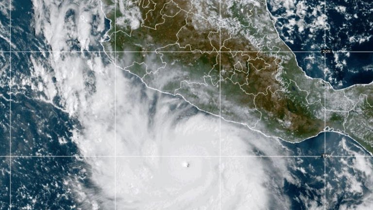
Hurricane Polo has undergone an extraordinary burst of rapid intensification off Mexico‘s Pacific coast, becoming a Category 5 hurricane with maximum sustained winds of 165 mph (266 km/h). The storm was churning hundreds of miles south of the Mexican coast on Tuesday, with its core forecast to remain offshore even as forecasters warned that dangerous weather could still reach coastal and inland areas.
Polo’s explosive strengthening has occurred as an unusually powerful El Niño develops across the tropical Pacific. The climate pattern is producing exceptionally warm ocean temperatures and atmospheric conditions that are supporting intense tropical cyclone activity in the eastern Pacific while contributing to unusually strong wind shear over the Atlantic.
The National Hurricane Center has warned of life-threatening Flooding and mudslides in parts of southwestern Mexico, along with dangerous surf and rip currents. Even if Polo avoids a direct landfall, its enormous circulation and moisture can produce serious impacts well away from the hurricane’s center.
Hurricane Polo reaches Category 5 strength
Polo was still a tropical storm on Monday, with sustained winds below hurricane strength. Within roughly a day, the system intensified dramatically and reached Category 5 status, the highest classification on the Saffir-Simpson Hurricane Wind Scale.
By Tuesday, maximum sustained winds had reached 165 mph, placing Polo among the most powerful tropical cyclones of the 2026 season. The National Hurricane Center’s advisories documented the storm’s rapid strengthening as it moved slowly near Mexico’s Pacific coast.
The speed of the transformation is particularly notable. Polo went from a tropical storm to an exceptionally powerful major hurricane in a very short period, demonstrating how quickly tropical cyclones can strengthen when oceanic and atmospheric conditions align.
Forecasters have continued to monitor the storm closely because rapid intensification can make preparation more difficult. A storm that appears relatively manageable one day can become a major hurricane before communities have much time to respond.
Polo is expected to remain offshore, but Mexico still faces serious risks
The center of Hurricane Polo was located roughly 215 miles south of Zihuatanejo, Guerrero, as the storm intensified. Forecast guidance indicated that Mexico was unlikely to receive a direct strike from Polo’s core, but that did not eliminate the threat.
Large tropical systems can affect land areas even when their centers remain offshore. Strong winds, heavy rainfall, large waves, dangerous surf and powerful rip currents can extend far beyond the eye and eyewall.
Guerrero and Michoacán were among the areas facing the greatest rainfall concerns. Forecasts indicated that several inches of rain could fall across portions of southwestern Mexico, with locally higher totals possible. Such rainfall can rapidly overwhelm drainage systems, trigger flash flooding and destabilize hillsides.
Mountainous terrain makes the threat of mudslides particularly important. Saturated soil can become unstable after prolonged or intense rainfall, creating hazards for roads, homes and communities located near steep slopes.
For coastal residents and visitors, the danger is not limited to rainfall. Powerful swells and rip currents can make beaches extremely hazardous, even in places that remain outside the hurricane’s strongest winds.
Why Hurricane Polo intensified so quickly
The rapid strengthening of Polo is closely connected to the unusual environmental conditions across the eastern Pacific. Hurricanes require several ingredients to intensify, including warm ocean water, abundant atmospheric moisture and relatively low vertical wind shear.
Warm water provides energy to a developing tropical cyclone. As water evaporates from the ocean surface, heat and moisture are transferred into the atmosphere. A well-organized storm can convert that energy into stronger winds and lower central pressure.
When wind shear is weak, the circulation of a tropical cyclone can remain vertically aligned. That allows the storm’s thunderstorms to concentrate around the center rather than being displaced by stronger winds at different atmospheric levels.
Polo has developed in an environment where unusually warm Pacific waters and other favorable atmospheric conditions have supported rapid strengthening. The result has been an exceptionally fast transition from a relatively modest tropical system into a Category 5 hurricane.
Strong El Niño is reshaping Pacific and Atlantic hurricane activity
The larger climate backdrop is the strengthening El Niño in the tropical Pacific. NOAA’s September assessment said El Niño had strengthened further, with sea-surface temperature anomalies exceeding 3 degrees Celsius in parts of the eastern equatorial Pacific. NOAA also gave a greater than 90% chance of a very strong El Niño during the Northern Hemisphere fall and winter of 2026-27.
El Niño occurs when sea-surface temperatures in the central and eastern equatorial Pacific become significantly warmer than their long-term average. The resulting changes in atmospheric circulation can influence weather patterns across large parts of the world.
Its effects on tropical cyclones are particularly important because the same climate pattern can create conditions that favor stronger activity in one ocean basin while suppressing storms in another.
In the Pacific, El Niño generally provides a more favorable background for tropical cyclone activity in parts of the eastern and central Pacific. Warmer waters and changes in atmospheric circulation can help storms develop and strengthen.
In the Atlantic, however, El Niño is commonly associated with increased vertical wind shear. Strong wind shear can disrupt the organization of tropical systems, making it more difficult for them to develop into hurricanes.
The Atlantic has experienced an extraordinary hurricane drought
The contrast between Polo’s explosive development and the quiet Atlantic has become one of the defining weather stories of the 2026 hurricane season.
As of September 21, the Atlantic basin had recorded six named storms but no hurricanes. National Hurricane Center data showed Atlantic activity well below the long-term average, with accumulated cyclone energy also substantially below normal.
The lack of an Atlantic hurricane this late in September is historically unusual. September is normally the climatological peak of Atlantic hurricane activity, and September 10 is generally regarded as the average peak date for the season.
Historical records show that only 1907 and 1914 had previously recorded no Atlantic hurricanes during an entire season. Whether 2026 ultimately joins those years remains uncertain because the Atlantic hurricane season continues through November 30.
The unusually quiet Atlantic is not being attributed to El Niño alone. Ocean temperatures, atmospheric moisture, wind patterns and other environmental factors all influence tropical cyclone formation. But the strengthening El Niño has created an important source of increased wind shear that can suppress storm development in the Atlantic.
Why El Niño can produce opposite effects in different oceans
El Niño is not simply a global switch that makes tropical storms stronger everywhere. Its effects depend on how changes in ocean temperatures alter atmospheric circulation over different regions.
Across the Pacific, the warmer tropical waters associated with El Niño can provide additional energy to developing storms. The eastern Pacific, in particular, can become a highly active environment for hurricanes when other ingredients are also favorable.
Across the Atlantic, the same broad atmospheric circulation can increase upper-level winds. This vertical wind shear can tilt or disrupt tropical systems before they have an opportunity to develop a stable circulation.
That contrast helps explain why Hurricane Polo can rapidly reach Category 5 intensity at the same time that the Atlantic remains without a hurricane deep into September.
Polo is part of an active Pacific hurricane season
Polo is one of a series of named storms to develop in the eastern Pacific during the 2026 hurricane season. The basin’s season officially runs from May 15 through November 30.
National Hurricane Center data showed that the eastern Pacific had already produced numerous named storms by late September, with several reaching hurricane strength. Polo’s development added another major system to an increasingly active period.
The eastern Pacific is particularly vulnerable to rapid changes in storm intensity because warm waters can remain close to the Mexican coastline. When a storm encounters an area of very warm water and favorable atmospheric conditions, its central pressure can fall rapidly and its winds can increase dramatically.
However, the presence of favorable conditions does not guarantee that every storm will become a major hurricane. Storm structure, wind shear, dry air, ocean temperatures beneath the surface and future track all influence how a hurricane evolves.
Rapid intensification makes forecasting more difficult
One of the biggest challenges presented by Polo is the speed at which its intensity changed. Forecasting the track of a hurricane is different from forecasting how strong it will become, and rapid intensification remains particularly difficult to predict.
When a storm strengthens much faster than expected, emergency authorities and residents can have less time to prepare for dangerous conditions. This is especially significant for coastal regions where large populations, tourism Infrastructure and transportation networks can be affected by heavy rain and high surf.
Polo also illustrates why forecasts should not focus solely on the center line of a hurricane. The projected track may keep the eye offshore while rainbands and dangerous marine conditions still affect communities along the coast.
For emergency managers, rainfall forecasts can therefore be as important as the projected landfall location. Flooding and mudslides can become life-threatening even when hurricane-force winds remain offshore.
Mexico’s Pacific coast remains vulnerable to flooding and mudslides
Southwestern Mexico has experienced destructive tropical cyclones in recent years, highlighting the risks posed by powerful Pacific storms. Terrain, drainage capacity and rainfall intensity can all influence how quickly a hurricane’s effects become dangerous.
Areas near rivers and streams can face rapid rises in water levels following intense rainfall. Roads crossing mountainous terrain can also become vulnerable to landslides, rockfalls and flooding.
Even where structural damage from hurricane winds is limited, prolonged rainfall can disrupt transportation, electricity and communications. Communities farther inland can also experience impacts because tropical moisture can Travel considerable distances from the storm’s center.
Residents in threatened areas therefore need to follow official warnings rather than assuming that an offshore track means there is no danger.
What happens next with Hurricane Polo?
The immediate focus for forecasters remains Polo’s intensity, movement and interaction with the environment around it. Because the storm has already undergone extremely rapid strengthening, small changes in atmospheric conditions could influence how long it maintains Category 5 strength.
The projected offshore path is an important factor for Mexico, but forecast uncertainty always increases farther into the future. A modest change in the hurricane’s direction can alter rainfall totals, wind exposure and coastal conditions for specific communities.
Forecasters are therefore continuing to monitor the system using Satellite observations, numerical weather models, aircraft and other meteorological data. Authorities along Mexico’s Pacific coast are also monitoring rainfall, flooding, surf and rip-current threats rather than relying solely on the forecast position of the hurricane’s center.
A striking contrast between the Pacific and Atlantic
Hurricane Polo’s explosive rise to Category 5 strength is a vivid example of how strongly climate patterns can shape tropical weather. A strengthening El Niño is helping create a highly active Pacific environment while contributing to atmospheric conditions that have suppressed Atlantic hurricane development.
The contrast is especially striking in late September, when the Atlantic would normally be near the heart of its hurricane season. Instead, the basin remains without a hurricane, while the eastern Pacific is producing a storm powerful enough to reach the highest category on the hurricane scale.
For Mexico, the immediate concern is not simply whether Polo makes landfall. Heavy rainfall, flash flooding, mudslides, dangerous surf and rip currents can threaten lives even if the hurricane’s core stays offshore.
Polo’s rapid intensification also serves as a reminder of how quickly tropical cyclone conditions can change when warm ocean water and favorable atmospheric conditions come together. With the Pacific hurricane season continuing into November, forecasters will continue watching for further systems developing under the influence of an unusually strong El Niño.
For breaking news and live news updates, like us on Facebook or follow us on Twitter and Instagram. Read more on Latest World on thefoxdaily.com.






COMMENTS 0